IMAGES TAKEN NEAR TO
Ozone Park, GOOLE, DN14 7SD
Introduction
This page details the photographs taken nearby to Ozone Park, DN14 7SD by members of the Geograph project.
The Geograph project started in 2005 with the aim of publishing, organising and preserving representative images for every square kilometre of Great Britain, Ireland and the Isle of Man.

There are currently over 7.5m images from over14,400 individuals and you can help contribute to the project by visiting https://www.geograph.org.uk
Image Map
Images are licensed for reuse under creativecommons.org/licenses/by-sa/2.0
Notes
- Clicking on the map will re-center to the selected point.
- The higher the marker number, the further away the image location is from the centre of the postcode.
Image Listing (14 Images Found)
Images are licensed for reuse under creativecommons.org/licenses/by-sa/2.0
Image
Details
Distance
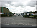
1
Farm track heading west off Booth Ferry Road
Image: © JThomas
Taken: 20 Aug 2010
0.06 miles
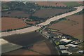
4
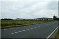
A63 Knedlington Road
Looking along the road leading to Boothferry Bridge and Goole. In the distance are various logistics company warehouses.
Image: © DS Pugh
Taken: 17 Jun 2023
0.13 miles
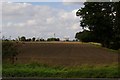
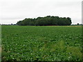
5
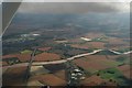
Fields beside the A63
Looking across farmland from Knedlington Road.
Image: © DS Pugh
Taken: 17 Jun 2023
0.17 miles
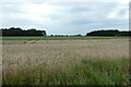
7
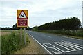
Sign on the A63
Looking north along Knedlington Road.
Image: © DS Pugh
Taken: 17 Jun 2023
0.18 miles