IMAGES TAKEN NEAR TO
Skelton, GOOLE, DN14 7RE
Introduction
This page details the photographs taken nearby to DN14 7RE by members of the Geograph project.
The Geograph project started in 2005 with the aim of publishing, organising and preserving representative images for every square kilometre of Great Britain, Ireland and the Isle of Man.

There are currently over 7.5m images from over14,400 individuals and you can help contribute to the project by visiting https://www.geograph.org.uk
Image Map
Images are licensed for reuse under creativecommons.org/licenses/by-sa/2.0
Notes
- Clicking on the map will re-center to the selected point.
- The higher the marker number, the further away the image location is from the centre of the postcode.
Image Listing (22 Images Found)
Images are licensed for reuse under creativecommons.org/licenses/by-sa/2.0
Image
Details
Distance
1

Old Chapel facing the River Ouse at Kilpin Pike
Image: © Chris Morgan
Taken: 30 Oct 2017
0.02 miles
2
Looking to Hook
View cross the River Ouse at Skelton towards the village of Hook on the western bank.
Image: © Paul Harrop
Taken: 4 Oct 2009
0.07 miles
3
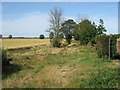
The Bridleway from Skelton
There must be a historical reason for the existence of this bridleway. Now it seems to have no purpose
Image: © Roger Gilbertson
Taken: 14 Jul 2006
0.08 miles
4
The Trans-Pennine Trail Through Skelton
The photograph was taken looking towards Kilpin Pike
Image: © Roger Gilbertson
Taken: 14 Jul 2006
0.08 miles
5
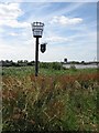
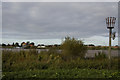
A Millennium Beacon
The inscription on the beacon is "KPC 2000", assumed to refer to a Millennium project by adjacent Kilpin Parish Council. The Port of Howden can be seen on the horizon
Image: © Roger Gilbertson
Taken: 14 Jul 2006
0.08 miles
6
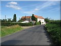
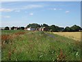
The Lane to Skelton from Kilpin Pike
Most users of the Trans-Pennine Trail are likely to follow the lane rather than the overgrown path on top of the embankment
Image: © Roger Gilbertson
Taken: 14 Jul 2006
0.08 miles
7

Landing stage and houses at Hook
As the house nearest the landing stage is on Hudscroft Drive, this may be Jenny Hudscroft Staith, which is name on the OS map, but not clearly defined.
Image: © Christine Johnstone
Taken: 24 Aug 2016
0.18 miles
8
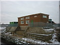
The pumping station at Skelton, East Yorkshire
Image: © Ian S
Taken: 26 Dec 2010
0.18 miles
9
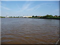
The River Ouse, north of Hook and Skelton
Looking upstream [locally north]. The river is the boundary between Hook [left / west] and Kilpin [right / east] civil parishes.
Image: © Christine Johnstone
Taken: 24 Aug 2016
0.18 miles
10
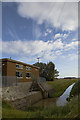
Skelton pumping station
On the north side of Skelton Broad Lane
Image: © Paul Harrop
Taken: 4 Oct 2009
0.19 miles