IMAGES TAKEN NEAR TO
Bishopsoil, GOOLE, DN14 7QW
Introduction
This page details the photographs taken nearby to Bishopsoil, DN14 7QW by members of the Geograph project.
The Geograph project started in 2005 with the aim of publishing, organising and preserving representative images for every square kilometre of Great Britain, Ireland and the Isle of Man.

There are currently over 7.5m images from over14,400 individuals and you can help contribute to the project by visiting https://www.geograph.org.uk
Image Map
Images are licensed for reuse under creativecommons.org/licenses/by-sa/2.0
Notes
- Clicking on the map will re-center to the selected point.
- The higher the marker number, the further away the image location is from the centre of the postcode.
Image Listing (14 Images Found)
Images are licensed for reuse under creativecommons.org/licenses/by-sa/2.0
Image
Details
Distance
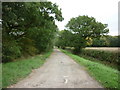
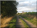
1
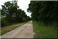
Barmby Lane, off Sleights Lane, between Portington and Hive
Image: © Chris
Taken: 16 Jul 2016
0.01 miles
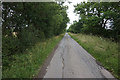
3
The Track To Bloomhill Farm
The entrance to Woodland View is on the right.
Image: © Roger Gilbertson
Taken: 11 Aug 2006
0.06 miles
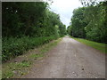
7
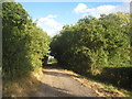
Track to Greave's End
Campbell's Wood on the right.
Image: © Jonathan Thacker
Taken: 8 Oct 2013
0.13 miles
8
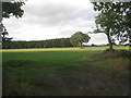
View towards a plantation
Taken from the lane that leads to Greave's End.
Image: © Jonathan Thacker
Taken: 8 Oct 2013
0.13 miles
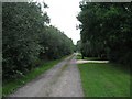
9
The track to Bloomhill Farm
Part of a network of such tracks linking local farms.
Image: © Jonathan Thacker
Taken: 8 Oct 2013
0.19 miles
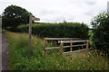
10
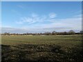
Crop field east of Carr Lane
A convenient entrance allows one to venture into this square without treading on any crops
Image: © David Brown
Taken: 28 Jan 2022
0.21 miles