IMAGES TAKEN NEAR TO
Owsthorpe, GOOLE, DN14 7QH
Introduction
This page details the photographs taken nearby to Owsthorpe, DN14 7QH by members of the Geograph project.
The Geograph project started in 2005 with the aim of publishing, organising and preserving representative images for every square kilometre of Great Britain, Ireland and the Isle of Man.

There are currently over 7.5m images from over14,400 individuals and you can help contribute to the project by visiting https://www.geograph.org.uk
Image Map
Images are licensed for reuse under creativecommons.org/licenses/by-sa/2.0
Notes
- Clicking on the map will re-center to the selected point.
- The higher the marker number, the further away the image location is from the centre of the postcode.
Image Listing (14 Images Found)
Images are licensed for reuse under creativecommons.org/licenses/by-sa/2.0
Image
Details
Distance
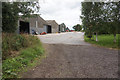
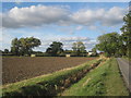
4
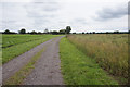
Approaching Manor Farm
Manor Farm has extensive buildings but all are hidden by the trees lining Owsthorpe Lane.
Image: © Jonathan Thacker
Taken: 8 Oct 2013
0.02 miles
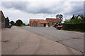
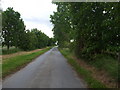
5
Owsthorpe lane and Manor Farm
It may be very flat here but the plentiful trees make a pleasing landscape.
Image: © Jonathan Thacker
Taken: 8 Oct 2013
0.06 miles
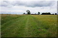
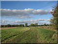
8
Wet edge to sown field north of Owsthorpe Farm
Image: © Martin Dawes
Taken: 20 Mar 2019
0.10 miles
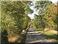
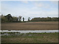
10
Bridleway from Manor Farm
Part of a network of byways and bridleways to the north of Eastrington.
Image: © Jonathan Thacker
Taken: 8 Oct 2013
0.22 miles