IMAGES TAKEN NEAR TO
Brind, GOOLE, DN14 7JZ
Introduction
This page details the photographs taken nearby to DN14 7JZ by members of the Geograph project.
The Geograph project started in 2005 with the aim of publishing, organising and preserving representative images for every square kilometre of Great Britain, Ireland and the Isle of Man.

There are currently over 7.5m images from over14,400 individuals and you can help contribute to the project by visiting https://www.geograph.org.uk
Image Map
Images are licensed for reuse under creativecommons.org/licenses/by-sa/2.0
Notes
- Clicking on the map will re-center to the selected point.
- The higher the marker number, the further away the image location is from the centre of the postcode.
Image Listing (7 Images Found)
Images are licensed for reuse under creativecommons.org/licenses/by-sa/2.0
Image
Details
Distance
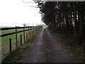
5
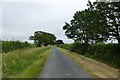
Brind Lane
Looking along Brind Lane towards Brind.
Image: © DS Pugh
Taken: 21 Jul 2013
0.19 miles
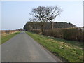
6
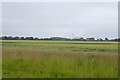
Towards Drax
The powerstation is visible from Brind Lane over the farmland.
Image: © DS Pugh
Taken: 21 Jul 2013
0.23 miles
7
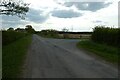
Lane junction
Both directions head towards Wressle, but approach from opposite ends of the village.
Image: © DS Pugh
Taken: 30 Apr 2022
0.24 miles