
IMAGES TAKEN NEAR TO
Charles Briggs Avenue, GOOLE, DN14 7FA
Introduction
This page details the photographs taken nearby to Charles Briggs Avenue, DN14 7FA by members of the Geograph project.
The Geograph project started in 2005 with the aim of publishing, organising and preserving representative images for every square kilometre of Great Britain, Ireland and the Isle of Man.

There are currently over 7.5m images from over14,400 individuals and you can help contribute to the project by visiting https://www.geograph.org.uk
Image Map
Images are licensed for reuse under creativecommons.org/licenses/by-sa/2.0
Notes
- Clicking on the map will re-center to the selected point.
- The higher the marker number, the further away the image location is from the centre of the postcode.
Image Listing (374 Images Found)
Images are licensed for reuse under creativecommons.org/licenses/by-sa/2.0
Image
Details
Distance
2
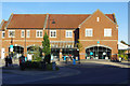
Howden-Hailgate Co-op
This is the larger of two Co-op stores in Howden. It is located on Charles Briggs Avenue, off Hailgate, and was built as part of a scheme that included housing, retirement homes and a public car park. Above the store are seven apartments.
Image: © Stephen McKay
Taken: 20 Sep 2019
0.04 miles
3
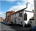
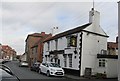
The Wheatsheaf, Howden
19th century town pub in Hailgate.
Image: © Gordon Hatton
Taken: 28 May 2009
0.04 miles
5
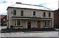
Highbridge House, Hailgate
Now used as officed for the East Riding council, this building has had many uses in its 300 year history. Built as a rather grand town house around 1700, it has served as a cinema and a club before being converted to offices.
Image: © Gordon Hatton
Taken: 28 May 2009
0.05 miles
7
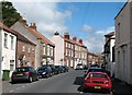
Hailgate, Howden
An unusual name for a street in a small town with a complicated street plan. Hailgate is said to curve along the old line of the River Derwent, which is now some 3 miles to the west.
Image: © Gordon Hatton
Taken: 28 May 2009
0.06 miles
8

Wheatsheaf on Hailgate, Howden
http://www.geograph.org.uk/photo/5052745
Image: © Ian S
Taken: 20 Jul 2016
0.06 miles
9
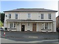
No.69, Hailgate, Highbridge House
A grade II listed house of 2 storeys, 5 bays, arranged 2-1-2 with central section breaking forward, (not 7 as described in the listing text and on the blue plaque). See Image
Dated early C18 with substantial C19 and C20 alterations. Rendered with ashlar dressings, rusticated quoins to angles, and a hipped,Welsh slate roof.
This house was formerly used as a cinema.
LBS No:- 165337
Image: © Mike Kirby
Taken: 22 Oct 2014
0.06 miles
10
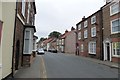
Hailgate
Looking along Hailgate in Howden.
Image: © DS Pugh
Taken: 21 Jul 2013
0.06 miles