IMAGES TAKEN NEAR TO
Asselby, GOOLE, DN14 7EY
Introduction
This page details the photographs taken nearby to DN14 7EY by members of the Geograph project.
The Geograph project started in 2005 with the aim of publishing, organising and preserving representative images for every square kilometre of Great Britain, Ireland and the Isle of Man.

There are currently over 7.5m images from over14,400 individuals and you can help contribute to the project by visiting https://www.geograph.org.uk
Image Map (Loading...)


Getting Data...Please wait
Leaflet Map data © OpenStreetMap
Images are licensed for reuse under creativecommons.org/licenses/by-sa/2.0
Notes
- Clicking on the map will re-center to the selected point.
- The higher the marker number, the further away the image location is from the centre of the postcode.
Image Listing (66 Images Found)
Images are licensed for reuse under creativecommons.org/licenses/by-sa/2.0
Image
Details
Distance
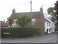
3
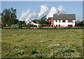
Cloudless Skies over Asselby
Or cloudless they would be, were it not for the power station at Drax. Looking towards the Old School House on the south side of Asselby Main Street from the field just west of Mill House.
Image: © Paul Glazzard
Taken: 5 Oct 2007
0.03 miles
5
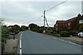
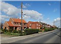
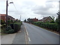
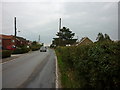
Road entering Asselby
The road runs between Barmby and Howden and forms part of National Cycle Network Route 65.
Image: © DS Pugh
Taken: 17 Jun 2023
0.04 miles
6
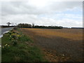
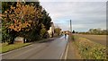
Farmland Between Asselby and Knedlington
Image: © Jonathan Clitheroe
Taken: 2 Apr 2016
0.05 miles