IMAGES TAKEN NEAR TO
Buttfield Road, GOOLE, DN14 7DY
Introduction
This page details the photographs taken nearby to Buttfield Road, DN14 7DY by members of the Geograph project.
The Geograph project started in 2005 with the aim of publishing, organising and preserving representative images for every square kilometre of Great Britain, Ireland and the Isle of Man.

There are currently over 7.5m images from over14,400 individuals and you can help contribute to the project by visiting https://www.geograph.org.uk
Image Map
Images are licensed for reuse under creativecommons.org/licenses/by-sa/2.0
Notes
- Clicking on the map will re-center to the selected point.
- The higher the marker number, the further away the image location is from the centre of the postcode.
Image Listing (12 Images Found)
Images are licensed for reuse under creativecommons.org/licenses/by-sa/2.0
Image
Details
Distance
5
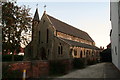
Catholic Church of the Sacred Heart
On the corner of Treeton Road and Buttfield Road.
Image: © Chris
Taken: 22 Sep 2013
0.19 miles
6
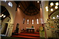
Sacred Heart Church, Howden
Inside Sacred Heart Church, Howden
Image: © Ashley Lightfoot
Taken: 26 Aug 2007
0.19 miles
7
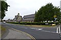
Sacred Heart Church
Looking along Buttfield Road from the junction with Treeton Road.
Image: © DS Pugh
Taken: 21 Jul 2013
0.19 miles
8
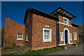
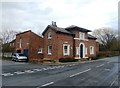
The Old Police Station, Howden
At the junction of Pinfold Street and Treeton Road, it was built in 1843 as a superintendent’s house with cells. It was designed by Henry Lockwood, who
erected similar buildings in Driffield and Market Weighton. He was also the architect of Trinity House in Hull and, with his partner William Mawson, designed the model industrial town at Saltaire in West Yorkshire.
Image: © Paul Harrop
Taken: 19 Apr 2009
0.23 miles
9
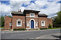
The Old Police Station in Howden
Former Superintendent's house located on the corner of Pinfold Street and Treeton Road. Howden Civic Society have erected an impressive array of plaques in the town highlighting places and buildings of note and one can be seen attached to this fine building.
Image: © Jonathan Clitheroe
Taken: 2 Apr 2016
0.23 miles
10
The Old Police Station
A blue plaque erected by Howden Civic Society reads "Built in 1843 as a Superintendent's house with cells, this fine building was designed by Henry Lockwood, who erected similar buildings in Driffield and Market Weighton. He was also the architect of Trinity House in Hull and, with his partner William Mawson, designed the mills at Saltaire"
Image: © Graham Hogg
Taken: 28 May 2015
0.24 miles