IMAGES TAKEN NEAR TO
Doyle Street, GOOLE, DN14 5YP
Introduction
This page details the photographs taken nearby to Doyle Street, DN14 5YP by members of the Geograph project.
The Geograph project started in 2005 with the aim of publishing, organising and preserving representative images for every square kilometre of Great Britain, Ireland and the Isle of Man.

There are currently over 7.5m images from over14,400 individuals and you can help contribute to the project by visiting https://www.geograph.org.uk
Image Map
Images are licensed for reuse under creativecommons.org/licenses/by-sa/2.0
Notes
- Clicking on the map will re-center to the selected point.
- The higher the marker number, the further away the image location is from the centre of the postcode.
Image Listing (176 Images Found)
Images are licensed for reuse under creativecommons.org/licenses/by-sa/2.0
Image
Details
Distance
1
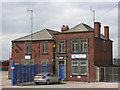
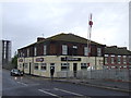
Former Gas Works Office
The main gas works for the town formerly occupied this site, the office is all that is left and has become the centre for a haulier's yard.
Image: © George Robinson
Taken: 11 Apr 2007
0.02 miles
2
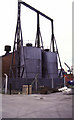
Goole Docks hydraulic power house
Two very nice hydraulic accumulators - now scrapped. The building behind contained the water hydraulic power pumps. We saw these through a window and I believe the plate on the control panel was that of Fullerton, Hodgart & Barclay.
The building still stands and is seen in somebody else's photograph.
This was a day trip with a gap and my suggestion in the car on the way up that we do Goole was not warmly received. However, we were not disappointed and the docks were well worth a visit.
Image: © Chris Allen
Taken: 15 Mar 1987
0.03 miles
4
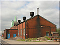
Pumphouse, South Dock
This building formerly housed three electrical pumps which primed the hydraulic power system for the port, water was pumped up into accumulator towers and thence to various appliances.
Image: © George Robinson
Taken: 11 Apr 2007
0.04 miles
5
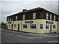
Vermuyden Hotel at northern end of bridge
The bridge to the right of the Vermuyden Hotel, carries the A161 across the 'Dutch River'. There's a connection: the so-called Dutch River is the massively diverted River Don, an engineering feat achieved by Dutchman, Cornelius Vermuyden in the seventeenth century. The silver, vertical tanks store edible oils.
Image: © Trevor Littlewood
Taken: 30 Jun 2020
0.04 miles
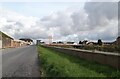
8
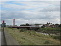
Road Bridge crossing Dutch River to Old Goole
Goole on the left bank, Old Goole on the right
Image: © Martin Dawes
Taken: 17 Sep 2012
0.04 miles
10
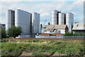
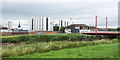
Edible oil tanks at Goole Docks
Between the two groups of silos can be seen two water towers, one in brick. The building seen centrally is The Vermuyden Hotel.
The view is across Dutch River from the A161, Swinefleet Road.
Image: © Trevor Littlewood
Taken: 4 Aug 2018
0.04 miles