IMAGES TAKEN NEAR TO
Wentworth Drive, GOOLE, DN14 5XS
Introduction
This page details the photographs taken nearby to Wentworth Drive, DN14 5XS by members of the Geograph project.
The Geograph project started in 2005 with the aim of publishing, organising and preserving representative images for every square kilometre of Great Britain, Ireland and the Isle of Man.

There are currently over 7.5m images from over14,400 individuals and you can help contribute to the project by visiting https://www.geograph.org.uk
Image Map
Images are licensed for reuse under creativecommons.org/licenses/by-sa/2.0
Notes
- Clicking on the map will re-center to the selected point.
- The higher the marker number, the further away the image location is from the centre of the postcode.
Image Listing (24 Images Found)
Images are licensed for reuse under creativecommons.org/licenses/by-sa/2.0
Image
Details
Distance
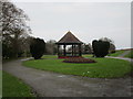
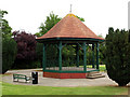
3
Bandstand needing repair
At Riverside Gardens
Image: © Kevin Waterhouse
Taken: 18 Sep 2023
0.17 miles

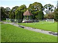
8
Riverside Bandstand
Located a few metres just north of the River Ouse river embankment.
Image: © Andy Beecroft
Taken: 8 Jul 2009
0.19 miles
9
The Yorkshire Ouse at Goole
The River Ouse seen north of the town's docks from the flood defence embankment above Hook Road.
Image: © Trevor Littlewood
Taken: 25 Dec 2011
0.20 miles
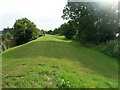
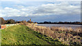
10
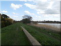
River Ouse, Flood Bank and Path
Looking downriver from a muddy path on the outskirts of Goole.
Image: © Jonathan Clitheroe
Taken: 9 Apr 2016
0.20 miles