IMAGES TAKEN NEAR TO
Wroots Avenue, GOOLE, DN14 5UD
Introduction
This page details the photographs taken nearby to Wroots Avenue, DN14 5UD by members of the Geograph project.
The Geograph project started in 2005 with the aim of publishing, organising and preserving representative images for every square kilometre of Great Britain, Ireland and the Isle of Man.

There are currently over 7.5m images from over14,400 individuals and you can help contribute to the project by visiting https://www.geograph.org.uk
Image Map
Images are licensed for reuse under creativecommons.org/licenses/by-sa/2.0
Notes
- Clicking on the map will re-center to the selected point.
- The higher the marker number, the further away the image location is from the centre of the postcode.
Image Listing (51 Images Found)
Images are licensed for reuse under creativecommons.org/licenses/by-sa/2.0
Image
Details
Distance
1
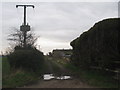
Lane behind Wroots Avenue
Leads out into Goole Fields.
Image: © Jonathan Thacker
Taken: 11 Mar 2011
0.05 miles
2
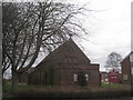
The former St. Mary's church, Old Goole
Like its Roman Catholic counterpart Image in Old Goole, now closed and subsequently demolished.
Image: © Jonathan Thacker
Taken: 11 Mar 2011
0.10 miles
3
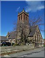
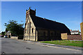
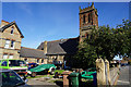
St Thomas's R.C. Church, Old Goole
Part of an Edwardian religious and school complex, the church is now disused.
Image: © Neil Theasby
Taken: 11 Mar 2019
0.11 miles
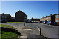
10
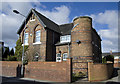
Old Convent, Old Goole
Building in Moorland Road, now converted to private residential use, next to the former school and the now derelict Image
Image: © Paul Harrop
Taken: 28 Mar 2010
0.12 miles