IMAGES TAKEN NEAR TO
Cottingham Street, GOOLE, DN14 5RP
Introduction
This page details the photographs taken nearby to Cottingham Street, DN14 5RP by members of the Geograph project.
The Geograph project started in 2005 with the aim of publishing, organising and preserving representative images for every square kilometre of Great Britain, Ireland and the Isle of Man.

There are currently over 7.5m images from over14,400 individuals and you can help contribute to the project by visiting https://www.geograph.org.uk
Image Map (Loading...)


Getting Data...Please wait
Leaflet Map data © OpenStreetMap
Images are licensed for reuse under creativecommons.org/licenses/by-sa/2.0
Notes
- Clicking on the map will re-center to the selected point.
- The higher the marker number, the further away the image location is from the centre of the postcode.
Image Listing (120 Images Found)
Images are licensed for reuse under creativecommons.org/licenses/by-sa/2.0
Image
Details
Distance
1
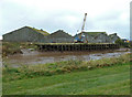
Wharf on the Dutch River
The Dutch River, or old River Don, is tidal
Image: © Christine Johnstone
Taken: 17 Dec 2009
0.03 miles
2
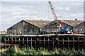
Priestman grab-arm crane
A long-disused crane on the south side of the Dutch River in Goole - the channel of the waterway can be seen beyond. The crane stands on the jetty that is adjacent to the old Fisons premises, also long disused.
Image: © Trevor Littlewood
Taken: 30 Jun 2020
0.04 miles
3
A walk from Goole #58
Walking down Hook Pasture Lane.
Image: © Ian S
Taken: 2 Aug 2010
0.04 miles
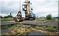
4
Abandoned crane
At the site of a former wharf on the Dutch River.
Image: © Jonathan Thacker
Taken: 1 Aug 2011
0.04 miles
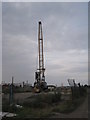
5
View across the Dutch River - Goole
The Dutch River is tidal and seen across it is a wharf with a Priestman grab crane. The buildings beyond are Yorkshire Feedstuffs.
Image: © Chris Allen
Taken: 9 Nov 2013
0.04 miles
6
Fison's Wharf across Dutch River
Fisons was a chemical and agricultural business which was absorbed into Rhône -Poulenc in 1995. Its presence in Goole was possibly associated with nearby peat extraction. The view is across the 'Dutch River' which carries the water of the greatly realigned River Don.
Image: © Trevor Littlewood
Taken: 15 Aug 2004
0.04 miles
7
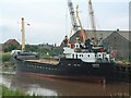
Dutch River Wharf
This small wharf once served a fertiliser works operated by Fisons but now handles a variety of bulk cargoes into storage sheds.
Image: © George Robinson
Taken: 3 Jul 2003
0.05 miles
8
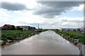
Goole: The Dutch River
Looking west from the A161 bridge. This artificial waterway is dangerous, and is definitely NOT navigable. There is a vicious and unpredictable tide rip, and the banks are completely inhospitable, consisting of a mixture of oozy mud and sharp jagged rocks. Small craft coming up the Ouse have sometimes gone astray by turning in here, mistaking it for the Knottingley and Goole Canal, to which there is NO access here. Such craft should enter Goole Docks through Ocean Lock after which a half-left turn will lead to the canal.
Image: © Dr Neil Clifton
Taken: 17 May 2010
0.06 miles
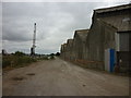
9
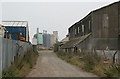
Jerry Lane, Old Goole
Shown on the maps as Hook Pasture Lane, there is a notice on the far end of the buildings to the right of this picture referring to one of the car breakers' yards (on the left here) as being "2nd right on Jerry Lane".
Looking up the lane you can see the restored Tom Pudding hoist and the grain silos in the main Goole docks.
Image: © Alan Murray-Rust
Taken: 7 Oct 2007
0.08 miles
10
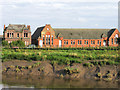
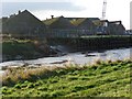
Old Goole Board School
Old Goole Board School in Old Goole before its demolition.
The view is across the 'Dutch River', which is tidal and carries the massively diverted waters of the River Don, - hence the muddy slope.
(Thanks to Patsy Kearsley for providing me with the correct name for this school.)
Image: © Trevor Littlewood
Taken: 15 Aug 2004
0.09 miles