IMAGES TAKEN NEAR TO
River Close, GOOLE, DN14 5LL
Introduction
This page details the photographs taken nearby to River Close, DN14 5LL by members of the Geograph project.
The Geograph project started in 2005 with the aim of publishing, organising and preserving representative images for every square kilometre of Great Britain, Ireland and the Isle of Man.

There are currently over 7.5m images from over14,400 individuals and you can help contribute to the project by visiting https://www.geograph.org.uk
Image Map (Loading...)


Getting Data...Please wait
Leaflet Map data © OpenStreetMap
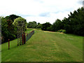
Images are licensed for reuse under creativecommons.org/licenses/by-sa/2.0
Notes
- Clicking on the map will re-center to the selected point.
- The higher the marker number, the further away the image location is from the centre of the postcode.
Image Listing (30 Images Found)
Images are licensed for reuse under creativecommons.org/licenses/by-sa/2.0
Image
Details
Distance
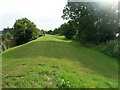
2
River Ouse, Flood Bank and Path
Looking downriver from a muddy path on the outskirts of Goole.
Image: © Jonathan Clitheroe
Taken: 9 Apr 2016
0.06 miles


9
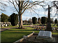
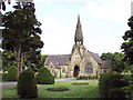
Hook Road Cemetery, Goole
Hook Road Cemetery in Goole is a large burial ground. The book-form monument in the foreground is an unusual one; it remembers sixteen Goole citizens killed on 9th. August 1915 in a Zeppelin raid.
Image: © Trevor Littlewood
Taken: 25 Dec 2011
0.13 miles
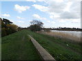
10
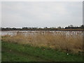
The River Ouse
Looking slightly upstream and towards Sand Hall.
Image: © Jonathan Thacker
Taken: 10 Feb 2017
0.14 miles