IMAGES TAKEN NEAR TO
Bittern Close, GOOLE, DN14 5BX
Introduction
This page details the photographs taken nearby to Bittern Close, DN14 5BX by members of the Geograph project.
The Geograph project started in 2005 with the aim of publishing, organising and preserving representative images for every square kilometre of Great Britain, Ireland and the Isle of Man.

There are currently over 7.5m images from over14,400 individuals and you can help contribute to the project by visiting https://www.geograph.org.uk
Image Map
Images are licensed for reuse under creativecommons.org/licenses/by-sa/2.0
Notes
- Clicking on the map will re-center to the selected point.
- The higher the marker number, the further away the image location is from the centre of the postcode.
Image Listing (21 Images Found)
Images are licensed for reuse under creativecommons.org/licenses/by-sa/2.0
Image
Details
Distance
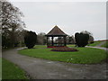
2
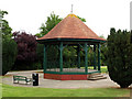
Riverside Bandstand
Located a few metres just north of the River Ouse river embankment.
Image: © Andy Beecroft
Taken: 8 Jul 2009
0.16 miles
3
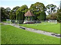
Bandstand needing repair
At Riverside Gardens
Image: © Kevin Waterhouse
Taken: 18 Sep 2023
0.16 miles
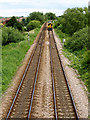
5
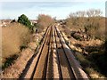
The Doncaster - Hull railway line
Looking north from a footbridge
Image: © Graham Hogg
Taken: 8 Dec 2014
0.17 miles
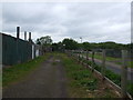
9
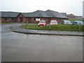
Sandhall Park
Nursing and residential care home http://www.mimosahealthcare.com. When opened over 10 years ago, it stood in open countryside, but is now practically surrounded by new housing.
Image: © Oliver Dixon
Taken: 23 Apr 2008
0.19 miles