IMAGES TAKEN NEAR TO
Downes Court, GOOLE, DN14 0WH
Introduction
This page details the photographs taken nearby to Downes Court, DN14 0WH by members of the Geograph project.
The Geograph project started in 2005 with the aim of publishing, organising and preserving representative images for every square kilometre of Great Britain, Ireland and the Isle of Man.

There are currently over 7.5m images from over14,400 individuals and you can help contribute to the project by visiting https://www.geograph.org.uk
Image Map
Images are licensed for reuse under creativecommons.org/licenses/by-sa/2.0
Notes
- Clicking on the map will re-center to the selected point.
- The higher the marker number, the further away the image location is from the centre of the postcode.
Image Listing (5 Images Found)
Images are licensed for reuse under creativecommons.org/licenses/by-sa/2.0
Image
Details
Distance
2
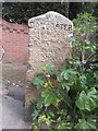
Old Milestone by the A19, Selby Road, Whitley village
Carved stone post by the A19, in parish of WHITLEY (SELBY District), South end of Whitley village, in front of new house, high wall, high wooden gates, on East side of road. Askern stone, erected by the Doncaster & Selby (new Trust) turnpike trust in the 19th century. Very weathered inscription.
Inscription reads:-
DONCASTER
11½ MILES
ASKERN 4½
SELBY 8½
YORK 23
North Yorkshire HER.
NY SMR Number: MNY36567 https://www.heritagegateway.org.uk/Gateway/Results_Single.aspx?uid=MNY36567&resourceID=1009
Milestone Society National ID: YN_DNSY11.
Image: © C Minto
Taken: 1 Mar 1993
0.05 miles