IMAGES TAKEN NEAR TO
Wand Lane, GOOLE, DN14 0RQ
Introduction
This page details the photographs taken nearby to Wand Lane, DN14 0RQ by members of the Geograph project.
The Geograph project started in 2005 with the aim of publishing, organising and preserving representative images for every square kilometre of Great Britain, Ireland and the Isle of Man.

There are currently over 7.5m images from over14,400 individuals and you can help contribute to the project by visiting https://www.geograph.org.uk
Image Map
Images are licensed for reuse under creativecommons.org/licenses/by-sa/2.0
Notes
- Clicking on the map will re-center to the selected point.
- The higher the marker number, the further away the image location is from the centre of the postcode.
Image Listing (13 Images Found)
Images are licensed for reuse under creativecommons.org/licenses/by-sa/2.0
Image
Details
Distance
1
Wand Lane, Hensall
Entering Hensall from the Eggborough Power Station road.
Image: © DS Pugh
Taken: 13 May 2018
0.01 miles
2
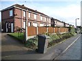
Houses on Wand Lane, Gallows Hill, west of Hensall
Five pairs of semis facing open countryside.
Image: © Christine Johnstone
Taken: 23 Jan 2016
0.02 miles
3
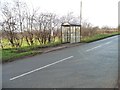
Westbound bus stop, Wand Lane, Gallows Hill
The logo on the shelter is a reminder that this part of the historical West Riding of Yorkshire is now in North Yorkshire.
Image: © Christine Johnstone
Taken: 23 Jan 2016
0.03 miles
4
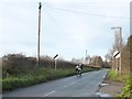
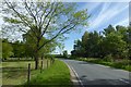
Cyclists heading west on Wand Lane, at Gallows Hill
Leaving Hensall's 30mph zone. The flat rural lanes of the lower Aire valley are popular with cyclists. Cycling is booming in Yorkshire since the Tour de France started in the county in 2014.
Image: © Christine Johnstone
Taken: 23 Jan 2016
0.06 miles
5
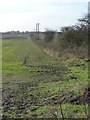
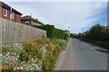
Field boundary with pylons, south of Wand Lane
As the field drops down a few metres towards West Common, it gets increasingly waterlogged.
Image: © Christine Johnstone
Taken: 23 Jan 2016
0.07 miles
6

Hensall, Railway Public Notice
These cast iron notices were common when I was a boy. The Lancashire and Yorkshire railway or Lank'e and York'e as it was known, was a forerunner of the old London Midland and Scottish Railway, the LMS as it was called. Some of these cast iron notice boards were in use right up to the railways being nationalised.
Image: © Gordon Kneale Brooke
Taken: 19 Sep 2006
0.08 miles
7
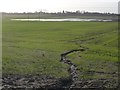
Waterlogged field, west of Hensall
With a flood run-off channel in the foreground [probably from localised flooding on Wand Lane].
Image: © Christine Johnstone
Taken: 23 Jan 2016
0.13 miles
8
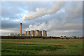
View from Station Road
Looking across to Eggborough Power Station and (right) Gallows Hill.
Image: © Alan Murray-Rust
Taken: 27 Dec 2011
0.14 miles
9
Bend on Wand Lane
Looking along Wand Lane to the west of Hensall.
Image: © DS Pugh
Taken: 13 May 2018
0.15 miles
10
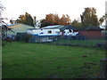
J J Tech Vans, Gallows Hill
Near Eggborough Power Station.
This is a former water works site and I think the two red brick buildings are part of that. They are not the original buildings as I believe this site had a pair of sizable 1933-4 Hathorn, Davey inverted vertical triple expansion engines that would have been in a larger building. Some sources call this Eggborough Waterworks although it is closer to Hensall. The waterworks house survives next door but I didn't see that at the time.
Image: © Chris Allen
Taken: 4 Nov 2017
0.15 miles