IMAGES TAKEN NEAR TO
Manor Farm Close, GOOLE, DN14 0PF
Introduction
This page details the photographs taken nearby to Manor Farm Close, DN14 0PF by members of the Geograph project.
The Geograph project started in 2005 with the aim of publishing, organising and preserving representative images for every square kilometre of Great Britain, Ireland and the Isle of Man.

There are currently over 7.5m images from over14,400 individuals and you can help contribute to the project by visiting https://www.geograph.org.uk
Image Map
Images are licensed for reuse under creativecommons.org/licenses/by-sa/2.0
Notes
- Clicking on the map will re-center to the selected point.
- The higher the marker number, the further away the image location is from the centre of the postcode.
Image Listing (18 Images Found)
Images are licensed for reuse under creativecommons.org/licenses/by-sa/2.0
Image
Details
Distance
3
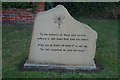
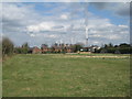
Kellington
Kellington and Eggborough Power Station seen from St.Edmunds church
Image: © Richard Croft
Taken: 4 Dec 2009
0.06 miles
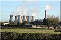
7
The southern end of Kellington and Eggborough power station
Image: © Jonathan Thacker
Taken: 19 Apr 2013
0.08 miles
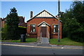
8
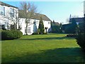
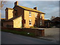
Old vicarage
The garden of Kellington old vicarage, now a small hotel.
Image: © James Allan
Taken: 31 Mar 2008
0.08 miles
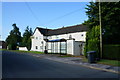
9
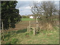
Stile near Kellington
This is on the path that leads from Kellington church to the centre of the village.
Image: © Jonathan Thacker
Taken: 19 Apr 2013
0.15 miles