IMAGES TAKEN NEAR TO
Hawthorn Garth, GOOLE, DN14 0PB
Introduction
This page details the photographs taken nearby to Hawthorn Garth, DN14 0PB by members of the Geograph project.
The Geograph project started in 2005 with the aim of publishing, organising and preserving representative images for every square kilometre of Great Britain, Ireland and the Isle of Man.

There are currently over 7.5m images from over14,400 individuals and you can help contribute to the project by visiting https://www.geograph.org.uk
Image Map
Images are licensed for reuse under creativecommons.org/licenses/by-sa/2.0
Notes
- Clicking on the map will re-center to the selected point.
- The higher the marker number, the further away the image location is from the centre of the postcode.
Image Listing (34 Images Found)
Images are licensed for reuse under creativecommons.org/licenses/by-sa/2.0
Image
Details
Distance
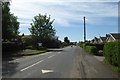
1
Eastfield Road, Kellington
Looking east from Main Street
Image: © Ian S
Taken: 10 Nov 2010
0.06 miles
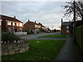
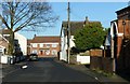
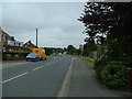
2
Eastfield Lane
Looking through the village of Kellington.
Image: © DS Pugh
Taken: 13 May 2018
0.08 miles
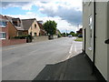
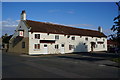
5
Main Street, Kellington
Looking towards the junction with Eastfield Lane.
Image: © Alan Murray-Rust
Taken: 9 Dec 2018
0.09 miles
6
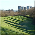
Flood bank at Kellington
Looking east from Marsh Lane.
Image: © Alan Murray-Rust
Taken: 9 Dec 2018
0.09 miles
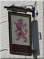
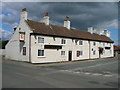
8
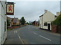
Kellington Centre
Looking from just by the Red Lion Pub near the junction of Ings Lane and Eastfield Lane, East towards Roall.
Image: © Simon Dean
Taken: 30 Jul 2005
0.09 miles
9
Kellington
Looking East along Eastfield Lane. There is also a Power Station in the distance on the right.
Image: © Simon Dean
Taken: 30 Jul 2005
0.09 miles