IMAGES TAKEN NEAR TO
Milton Walk, DONCASTER, DN1 3QJ
Introduction
This page details the photographs taken nearby to Milton Walk, DN1 3QJ by members of the Geograph project.
The Geograph project started in 2005 with the aim of publishing, organising and preserving representative images for every square kilometre of Great Britain, Ireland and the Isle of Man.

There are currently over 7.5m images from over14,400 individuals and you can help contribute to the project by visiting https://www.geograph.org.uk
Image Map (Loading...)


Getting Data...Please wait
Leaflet Map data © OpenStreetMap
Images are licensed for reuse under creativecommons.org/licenses/by-sa/2.0
Notes
- Clicking on the map will re-center to the selected point.
- The higher the marker number, the further away the image location is from the centre of the postcode.
Image Listing (12 Images Found)
Images are licensed for reuse under creativecommons.org/licenses/by-sa/2.0
Image
Details
Distance
1
Entrance Arch to Hyde Park Cemetery
Image: © Siobhan Brennan-Raymond
Taken: Unknown
0.08 miles
5

Ivy Covered Tomb
Hyde Park Cemetery
Image: © Siobhan Brennan-Raymond
Taken: Unknown
0.17 miles

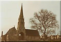
7
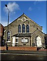
The Church of God of Prophecy, Doncaster
On Carr House Road, Hyde Park. The building began its life as a Methodist chapel in 1891, serving the surrounding neighbourhood.
Image: © Neil Theasby
Taken: 9 Feb 2020
0.18 miles
8

What was Coal House
Once the centre of the Coal Board.
Image: © Steve Fareham
Taken: 2 Jul 2008
0.19 miles