IMAGES TAKEN NEAR TO
High Street, DONCASTER, DN1 1DE
Introduction
This page details the photographs taken nearby to High Street, DN1 1DE by members of the Geograph project.
The Geograph project started in 2005 with the aim of publishing, organising and preserving representative images for every square kilometre of Great Britain, Ireland and the Isle of Man.

There are currently over 7.5m images from over14,400 individuals and you can help contribute to the project by visiting https://www.geograph.org.uk
Image Map (Loading...)


Getting Data...Please wait
Leaflet Map data © OpenStreetMap
Images are licensed for reuse under creativecommons.org/licenses/by-sa/2.0
Notes
- Clicking on the map will re-center to the selected point.
- The higher the marker number, the further away the image location is from the centre of the postcode.
Image Listing (324 Images Found)
Images are licensed for reuse under creativecommons.org/licenses/by-sa/2.0
Image
Details
Distance
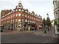
2
Number Fifteens, Doncaster
Bar on High Street.
Image: © JThomas
Taken: 19 Sep 2022
0.01 miles
3
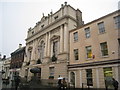
Doncaster Mansion House
Built for the Mayor of Doncaster as a residence and place where he could entertain visitors. Work began on it in 1745.
Image: © Jonathan Thacker
Taken: 7 Jan 2011
0.02 miles
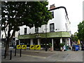
4
The Gate House public house
On Priory Walk, Doncaster.
Image: © Ian S
Taken: 15 May 2019
0.02 miles
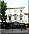
5
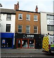
The GRiND, Doncaster
Restaurant, café, and bar on High Street.
Image: © JThomas
Taken: 19 Sep 2022
0.02 miles
7
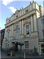
Doncaster Mansion House
Built for the Mayor of Doncaster as a residence and place where he could entertain visitors. Work began on it in 1745.
It is a Grade I listed building with a facade designed by James Paine.
Image: © David Anstiss
Taken: 12 Jul 2017
0.03 miles
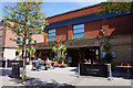
8
Doncaster - Scot Lane
Buildings on NW side of street.
Image: © Dave Bevis
Taken: 28 Jun 2011
0.03 miles
9
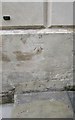
Ordnance Survey Cut Mark
This OS cut mark can be found on the NE face of the Mansion House. It marks a point 14.829m above mean sea level.
Image: © Adrian Dust
Taken: 27 May 2016
0.03 miles
10
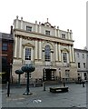
Doncaster Mansion House
Owned and managed by Doncaster Council, the venue is used for civic and private functions. Grade I listed.
Image: © JThomas
Taken: 19 Sep 2022
0.03 miles