IMAGES TAKEN NEAR TO
Common Lane, DONCASTER, DN11 9UF
Introduction
This page details the photographs taken nearby to Common Lane, DN11 9UF by members of the Geograph project.
The Geograph project started in 2005 with the aim of publishing, organising and preserving representative images for every square kilometre of Great Britain, Ireland and the Isle of Man.

There are currently over 7.5m images from over14,400 individuals and you can help contribute to the project by visiting https://www.geograph.org.uk
Image Map (Loading...)


Getting Data...Please wait
Leaflet Map data © OpenStreetMap
Images are licensed for reuse under creativecommons.org/licenses/by-sa/2.0
Notes
- Clicking on the map will re-center to the selected point.
- The higher the marker number, the further away the image location is from the centre of the postcode.
Image Listing (10 Images Found)
Images are licensed for reuse under creativecommons.org/licenses/by-sa/2.0
Image
Details
Distance
2
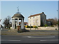
Buttercross, Tickhill
The Market Cross, Tickhill known locally as the Buttercross was built in 1777 by the Revd Christopher Alderson.
Image: © John Garfoot
Taken: 1 Apr 2007
0.20 miles
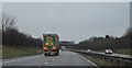
3
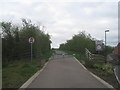
Barrier on Common Lane
The bridge over the A1(M) is closed to traffic.
Image: © Jonathan Thacker
Taken: 5 Apr 2014
0.20 miles
4
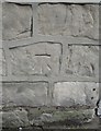
Ordnance Survey Cut Mark
This OS cut mark can be found on Barn House, North Gate. It marks a point 18.818m above mean sea level.
Image: © Adrian Dust
Taken: 22 May 2016
0.22 miles
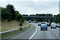
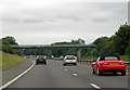
6
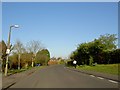
Tickhill : A1(M)
Heading along the A1(M).
Image: © Lewis Clarke
Taken: 21 Sep 2020
0.23 miles
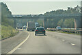
7
The A1(M)
Looking north from Common Lane bridge
Image: © Graham Hogg
Taken: 20 Oct 2015
0.23 miles
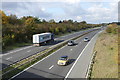
9
A1(M) Common Lane Bridge
Southbound east of Tickhill.
Image: © J.Hannan-Briggs
Taken: 15 Jun 2014
0.24 miles
10
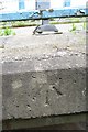
Ordnance Survey Rivet
This OS rivet can be found on the south parapet of the bridge on Common Lane over the motorway. It marks a point 18.989m above mean sea level.
Image: © Adrian Dust
Taken: 29 May 2016
0.25 miles