IMAGES TAKEN NEAR TO
Limestone Hill, DONCASTER, DN11 9PG
Introduction
This page details the photographs taken nearby to Limestone Hill, DN11 9PG by members of the Geograph project.
The Geograph project started in 2005 with the aim of publishing, organising and preserving representative images for every square kilometre of Great Britain, Ireland and the Isle of Man.

There are currently over 7.5m images from over14,400 individuals and you can help contribute to the project by visiting https://www.geograph.org.uk
Image Map (7 Images)


Getting Data...Please wait
Leaflet Map data © OpenStreetMap
Images are licensed for reuse under creativecommons.org/licenses/by-sa/2.0
Notes
- Clicking on the map will re-center to the selected point.
- The higher the marker number, the further away the image location is from the centre of the postcode.
Image Listing (7 Images Found)
Images are licensed for reuse under creativecommons.org/licenses/by-sa/2.0
Image
Details
Distance
1
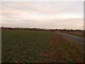
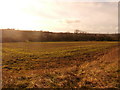
Crop Field near Limestone Hill Farm
Image: © Jonathan Clitheroe
Taken: 31 Dec 2015
0.12 miles
2
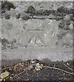
Ordnance Survey Cut Mark
This OS cut mark can be found on the wall to the south of the Rotherham Road. It marks a point 28.447m above mean sea level.
Image: © Adrian Dust
Taken: 22 May 2016
0.16 miles
3
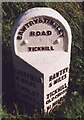
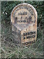
Old Milestone, on the A631, top of hill, E of Blyth Gate Lane
Located on the South side of road, on verge. Metal plate attached to stone post, Brayshaw & Booth casting design, 19th century.
Inscription reads: SHEFFIELD / 16 MILES / TINSLEY / 12 MILES / ROTHERHAM / (9¾ MILES ) // BAWTRY / 5 MILES / TICKHILL / OLD CROSS / 1¼ MILES // BAWTRY & TINSLEY / ROAD / TICKHILL // BRAYSHAW & BOOTH / MAKERS / LIVERSEDGE
Milestone Society National ID: YS_TYBW12
Image: © Christine Minto
Taken: Unknown
0.18 miles
4
Old milestone
The photograph of this milestone in the previous submission https://www.geograph.org.uk/photo/6742870 was taken in 1992. It has not been painted since! These West Riding CC milestones date from 1893/94 when the family firm of Gill and Frank Stead of Mirfield won the contract to erect 615 stones all over the old West Riding within a 12 month period. They succeeded and didn't incur any penalty. Many of the metal attachments were cast at the Brayshaw & Booth foundry in Liversedge and that is cast on the bevel. This stone has a hole and benchmark on the top of the backing stone.
Image: © Chris Minto
Taken: 19 Oct 2014
0.18 miles
5
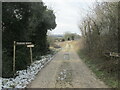
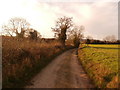
Hindley lane.
Looking back towards the Tickhill alpacha fields.
Image: © steven ruffles
Taken: 13 Feb 2021
0.20 miles
6
View Across Paper Mill Dike
Pictured from Hindley Lane.
Image: © Jonathan Clitheroe
Taken: 31 Dec 2015
0.21 miles