IMAGES TAKEN NEAR TO
Crown Road, DONCASTER, DN11 9PA
Introduction
This page details the photographs taken nearby to Crown Road, DN11 9PA by members of the Geograph project.
The Geograph project started in 2005 with the aim of publishing, organising and preserving representative images for every square kilometre of Great Britain, Ireland and the Isle of Man.

There are currently over 7.5m images from over14,400 individuals and you can help contribute to the project by visiting https://www.geograph.org.uk
Image Map (Loading...)


Getting Data...Please wait
Leaflet Map data © OpenStreetMap
Images are licensed for reuse under creativecommons.org/licenses/by-sa/2.0
Notes
- Clicking on the map will re-center to the selected point.
- The higher the marker number, the further away the image location is from the centre of the postcode.
Image Listing (23 Images Found)
Images are licensed for reuse under creativecommons.org/licenses/by-sa/2.0
Image
Details
Distance
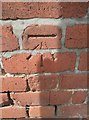
2
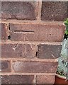
Ordnance Survey Cut Mark
This OS cut mark can be found on No50 Pinfold Lane. It arks a point 31.413m above mean sea level.
Image: © Adrian Dust
Taken: 22 May 2016
0.09 miles
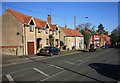
3
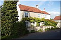
Little Beck
Sunlit cottage on Pinfold Lane
Image: © Graham Hogg
Taken: 20 Oct 2015
0.12 miles

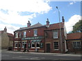
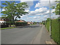
7
Tickhill
The outskirts of Tickhill near where the A60 enters the town.
Image: © roger geach
Taken: 31 Jan 2010
0.14 miles
8
Ordnance Survey Cut Mark
This OS cut mark can be found on the Travellers Rest PH. It marks a point 20.998m above mean sea level.
Image: © Adrian Dust
Taken: 22 May 2016
0.14 miles

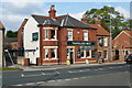
10
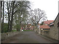
Old Worksop Road
Its replacement is to the left beyond the trees.
Image: © Jonathan Thacker
Taken: 5 Apr 2014
0.15 miles