IMAGES TAKEN NEAR TO
Doncaster Road, DONCASTER, DN11 9LH
Introduction
This page details the photographs taken nearby to Doncaster Road, DN11 9LH by members of the Geograph project.
The Geograph project started in 2005 with the aim of publishing, organising and preserving representative images for every square kilometre of Great Britain, Ireland and the Isle of Man.

There are currently over 7.5m images from over14,400 individuals and you can help contribute to the project by visiting https://www.geograph.org.uk
Image Map
Images are licensed for reuse under creativecommons.org/licenses/by-sa/2.0
Notes
- Clicking on the map will re-center to the selected point.
- The higher the marker number, the further away the image location is from the centre of the postcode.
Image Listing (4 Images Found)
Images are licensed for reuse under creativecommons.org/licenses/by-sa/2.0
Image
Details
Distance
1
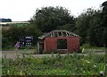
Former scrapyard by Oddy Lane
Close to a railway track, it is likely that this former scrapyard was once also a railways yard.
Image: © Neil Theasby
Taken: 9 Aug 2014
0.04 miles
3
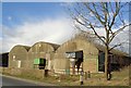
Curved roof Dutch barns on the A60 from Tickhill to Wadworth
The steel frame was supplied by a long since gone Teasdale and Metcalfe, I think were based near Wetherby.
Image: © Steve Fareham
Taken: 4 Mar 2008
0.14 miles
4
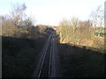
Railway to the A1
This single track branch line passes beneath the A1(M) just around the corner. The railway then goes on to nearby Doncaster. The shadow of someone taking a photograph can be seen in the cutting.
Image: © Michael Patterson
Taken: 22 Jan 2007
0.21 miles