IMAGES TAKEN NEAR TO
Stripe Road, DONCASTER, DN11 9HD
Introduction
This page details the photographs taken nearby to Stripe Road, DN11 9HD by members of the Geograph project.
The Geograph project started in 2005 with the aim of publishing, organising and preserving representative images for every square kilometre of Great Britain, Ireland and the Isle of Man.

There are currently over 7.5m images from over14,400 individuals and you can help contribute to the project by visiting https://www.geograph.org.uk
Image Map (Loading...)


Getting Data...Please wait
Leaflet Map data © OpenStreetMap
Images are licensed for reuse under creativecommons.org/licenses/by-sa/2.0
Notes
- Clicking on the map will re-center to the selected point.
- The higher the marker number, the further away the image location is from the centre of the postcode.
Image Listing (7 Images Found)
Images are licensed for reuse under creativecommons.org/licenses/by-sa/2.0
Image
Details
Distance
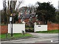
2
Wall and gateway corner of Bawtry Road and Stripe Road
Image: © SMJ
Taken: 2 Dec 2011
0.10 miles
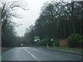
3
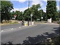
Wrong Way
This is a busy junction of the B6463 and the A631. The cyclist was distracted by the fact his back tyre was flat.
Image: © Michael Patterson
Taken: 14 Jul 2006
0.11 miles
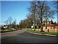
5
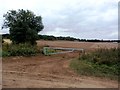
Ploughed Field Viewed from Sheepwash Lane
Sandrock Cottage by Stripe Road can be seen at the far end of the field.
Image: © Jonathan Clitheroe
Taken: 7 Oct 2016
0.14 miles
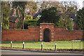
7
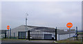
Exit gates from Moorhouse Farm Livery
Image: © Steve Fareham
Taken: 18 Dec 2007
0.24 miles