IMAGES TAKEN NEAR TO
Church Road, DONCASTER, DN11 9EF
Introduction
This page details the photographs taken nearby to Church Road, DN11 9EF by members of the Geograph project.
The Geograph project started in 2005 with the aim of publishing, organising and preserving representative images for every square kilometre of Great Britain, Ireland and the Isle of Man.

There are currently over 7.5m images from over14,400 individuals and you can help contribute to the project by visiting https://www.geograph.org.uk
Image Map (Loading...)


Getting Data...Please wait
Leaflet Map data © OpenStreetMap
Images are licensed for reuse under creativecommons.org/licenses/by-sa/2.0
Notes
- Clicking on the map will re-center to the selected point.
- The higher the marker number, the further away the image location is from the centre of the postcode.
Image Listing (33 Images Found)
Images are licensed for reuse under creativecommons.org/licenses/by-sa/2.0
Image
Details
Distance
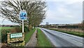
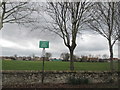
2
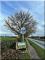
Wadworth village sign
On the B6094 Church Road approach to the village.
Image: © Graham Hogg
Taken: 6 Jan 2023
0.08 miles
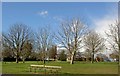
5
Wadworth cricket and football pitches
Probably not very interesting without a ball
Image: © John Slater
Taken: 23 Mar 2015
0.12 miles
6
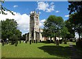
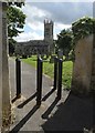
Wadworth Church
Dedicated to John the Baptist
Image: © Neil Theasby
Taken: 9 Aug 2014
0.15 miles
7
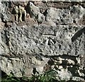
Ordnance Survey Cut Mark
This OS cut mark can be found on the south face of St John's Church. It marks a point 59.518m above mean sea level.
Image: © Adrian Dust
Taken: 23 May 2016
0.15 miles
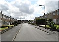
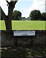
10
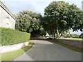
Wadworth Hall Lane in Wadworth
The older dwellings in Wadworth stand on a prominent ridge which offers commanding views north towards Doncaster. This view is towards the village centre with the church tower visible on the right.
Image: © Jonathan Clitheroe
Taken: 28 Sep 2016
0.15 miles