IMAGES TAKEN NEAR TO
Redhill Court, DONCASTER, DN11 9ED
Introduction
This page details the photographs taken nearby to Redhill Court, DN11 9ED by members of the Geograph project.
The Geograph project started in 2005 with the aim of publishing, organising and preserving representative images for every square kilometre of Great Britain, Ireland and the Isle of Man.

There are currently over 7.5m images from over14,400 individuals and you can help contribute to the project by visiting https://www.geograph.org.uk
Image Map (Loading...)


Getting Data...Please wait
Leaflet Map data © OpenStreetMap
Images are licensed for reuse under creativecommons.org/licenses/by-sa/2.0
Notes
- Clicking on the map will re-center to the selected point.
- The higher the marker number, the further away the image location is from the centre of the postcode.
Image Listing (35 Images Found)
Images are licensed for reuse under creativecommons.org/licenses/by-sa/2.0
Image
Details
Distance
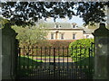
1
East Lodge, Wadworth Hall
Like the hall itself, the lodges either side of the gateway are part hidden behind trees and hedges, so details are obscured. The lodges are of a similar age to the hall, whilst the door surrounds are described by Harman/Pevsner as rather in the style of Vanbrugh.
Image: © Gordon Hatton
Taken: 20 Apr 2022
0.04 miles
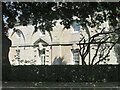
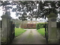
2
Wadworth Hall
Only the upper floors of this mid 18th century house are visible from the road, but it is described by Pevsner/Harman as 'A gracious house of no great size but nevertheless one of James Paine's most dramatic designs'.
Image: © Gordon Hatton
Taken: 20 Apr 2022
0.05 miles
3
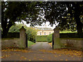
Entrance to Wadworth Hall
In the 1970's it was used as offices for the architects T H Johnson and Sons.
Image: © Steve Fareham
Taken: 16 Oct 2007
0.05 miles
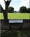
4
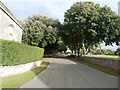
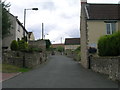
Wadworth Hall Lane in Wadworth
The older dwellings in Wadworth stand on a prominent ridge which offers commanding views north towards Doncaster. This view is towards the village centre with the church tower visible on the right.
Image: © Jonathan Clitheroe
Taken: 28 Sep 2016
0.06 miles
6
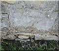
Ordnance Survey Cut Mark
This OS cut mark can be found on the east side wall of Tofield Road opposite the footpath. It marks a point 61.387m above mean sea level.
Image: © Adrian Dust
Taken: 23 May 2016
0.09 miles
7
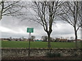
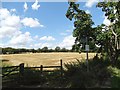
Wadworth cricket and football pitches
Probably not very interesting without a ball
Image: © John Slater
Taken: 23 Mar 2015
0.09 miles