IMAGES TAKEN NEAR TO
Wilsic, DONCASTER, DN11 9AF
Introduction
This page details the photographs taken nearby to DN11 9AF by members of the Geograph project.
The Geograph project started in 2005 with the aim of publishing, organising and preserving representative images for every square kilometre of Great Britain, Ireland and the Isle of Man.

There are currently over 7.5m images from over14,400 individuals and you can help contribute to the project by visiting https://www.geograph.org.uk
Image Map (Loading...)


Getting Data...Please wait
Leaflet Map data © OpenStreetMap
Images are licensed for reuse under creativecommons.org/licenses/by-sa/2.0
Notes
- Clicking on the map will re-center to the selected point.
- The higher the marker number, the further away the image location is from the centre of the postcode.
Image Listing (9 Images Found)
Images are licensed for reuse under creativecommons.org/licenses/by-sa/2.0
Image
Details
Distance
3
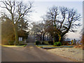
The entrance to Wilsic Hall School
http://www.isbi.com/isbi-viewschool/1913-WILSIC_HALL_SCHOOL.html
Image: © Steve Fareham
Taken: 12 Feb 2008
0.09 miles
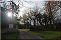
4
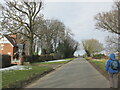
Entrance to Wilsic Hall School
Wilsic Lane continues towards Tickhill on the left of picture.
Image: © Jonathan Clitheroe
Taken: 28 Sep 2016
0.13 miles
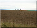
7
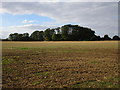
View towards a plantation by Long Gate
Image: © Jonathan Thacker
Taken: 26 Sep 2015
0.15 miles
8
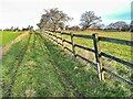
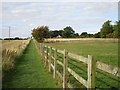
Boundary fence
Beside the public footpath to the west of Wilsic.
Image: © Graham Hogg
Taken: 6 Jan 2023
0.16 miles
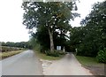
9
The end of Wilsic Road
Walking back to Wadworth.
Image: © steven ruffles
Taken: 13 Feb 2021
0.16 miles