IMAGES TAKEN NEAR TO
Styrrup Road, DONCASTER, DN11 8LL
Introduction
This page details the photographs taken nearby to Styrrup Road, DN11 8LL by members of the Geograph project.
The Geograph project started in 2005 with the aim of publishing, organising and preserving representative images for every square kilometre of Great Britain, Ireland and the Isle of Man.

There are currently over 7.5m images from over14,400 individuals and you can help contribute to the project by visiting https://www.geograph.org.uk
Image Map
Images are licensed for reuse under creativecommons.org/licenses/by-sa/2.0
Notes
- Clicking on the map will re-center to the selected point.
- The higher the marker number, the further away the image location is from the centre of the postcode.
Image Listing (29 Images Found)
Images are licensed for reuse under creativecommons.org/licenses/by-sa/2.0
Image
Details
Distance
1

Airey Houses, Styrrup Road, Harworth
A prefabricated house developed following WW2. http://en.wikipedia.org/wiki/Airey_house This group is largely in original condition. Deterioration of the concrete means that modernisation is usually essential to be able to obtain a mortgage on this type of house. Oddly enough the one modernised house visible far right is boarded up.
Image: © Alan Murray-Rust
Taken: 24 Nov 2014
0.03 miles
2

Syringa Court, Styrrup Road
Barn conversion to residential use, an example of how this can be achieved with minimal alteration to the appearance of the building, with windows all facing to the rear. The main doors have been left unfilled to provide the impression of the space through the barn, even though new internal walls have bee constructed. Early 19th century, Listed Grade II for group value.
Image: © Alan Murray-Rust
Taken: 24 Nov 2014
0.07 miles
3

Syringa House, Styrrup Road
Late 18th century farmhouse. Listed Grade II.
Image: © Alan Murray-Rust
Taken: 24 Nov 2014
0.09 miles
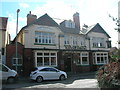
4
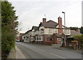
Blacksmiths Arms, Harworth
A large public house, probably dating from the time of the development of the colliery in the early 1920s.
Image: © Alan Murray-Rust
Taken: 24 Nov 2014
0.13 miles
5
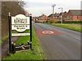
Harworth and Bircotes village sign
In contrast to the version on Scrooby Road http://www.geograph.org.uk/photo/4259640 , this illustrates Harworth Church.
Image: © Alan Murray-Rust
Taken: 24 Nov 2014
0.13 miles
7
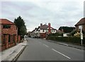
Main Street in Harworth
The public house in the centre of picture is the Blacksmiths Arms.
Image: © Jonathan Clitheroe
Taken: 7 Oct 2016
0.14 miles
8

Church of All Saints, Harworth
South porch and door.
It is a telling commentary on current social attitudes that it has been found necessary to make a place of worship look like a fortress.
Image: © Alan Murray-Rust
Taken: 24 Nov 2014
0.16 miles
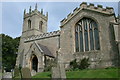
10

Church of All Saints, Harworth
View from the south west. On the south and west sides the land drops away steeply from the church. The tower is Early English 12th century. Listed Grade II.
Image: © Alan Murray-Rust
Taken: 24 Nov 2014
0.17 miles