IMAGES TAKEN NEAR TO
Scrooby Road, DONCASTER, DN11 8JN
Introduction
This page details the photographs taken nearby to Scrooby Road, DN11 8JN by members of the Geograph project.
The Geograph project started in 2005 with the aim of publishing, organising and preserving representative images for every square kilometre of Great Britain, Ireland and the Isle of Man.

There are currently over 7.5m images from over14,400 individuals and you can help contribute to the project by visiting https://www.geograph.org.uk
Image Map
Images are licensed for reuse under creativecommons.org/licenses/by-sa/2.0
Notes
- Clicking on the map will re-center to the selected point.
- The higher the marker number, the further away the image location is from the centre of the postcode.
Image Listing (34 Images Found)
Images are licensed for reuse under creativecommons.org/licenses/by-sa/2.0
Image
Details
Distance
1
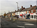
Bircotes shopping centre
These would have been among the earliest buildings to be built, around 1920, in the then new mining village of Bircotes.
Image: © Alan Murray-Rust
Taken: 24 Nov 2014
0.03 miles
2

D.I.Y. store on Scrooby Road, Harworth
Image: © Neil Theasby
Taken: 12 Jan 2016
0.03 miles


5

Bench mark, Bircotes Library
See http://www.geograph.org.uk/photo/4259648 for location.
Image: © Alan Murray-Rust
Taken: 24 Nov 2014
0.08 miles
6
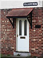
House detail - Colliery Road, Harworth
As the name of the street suggests, it led directly to the old colliery gates.
Image: © Neil Theasby
Taken: 12 Jan 2016
0.08 miles
8
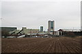
Harworth Colliery
The first shaft was sunk in 1919 and Harworth pit has produced millions of tons of top quality coal ever since. The Flying Scotsman was burning Harworth Coal when she covered the 392 miles from London to Edinburgh in 7 hours, 27 minutes in 1932.
Image: © Richard Croft
Taken: 13 Jan 2006
0.08 miles
9

Bircotes Library
Purpose built, in the late 1950s. There is a bench mark http://www.geograph.org.uk/photo/4259652 on the far corner (side wall).
Image: © Alan Murray-Rust
Taken: 24 Nov 2014
0.09 miles
10
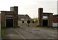
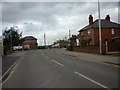
Old colliery entrance gates, Colliery Road, Bircotes
Even by the 1930s this would not have been the main vehicle entrance to the mine.
Image: © Alan Murray-Rust
Taken: 24 Nov 2014
0.09 miles