IMAGES TAKEN NEAR TO
Swan Court, DONCASTER, DN11 8BF
Introduction
This page details the photographs taken nearby to Swan Court, DN11 8BF by members of the Geograph project.
The Geograph project started in 2005 with the aim of publishing, organising and preserving representative images for every square kilometre of Great Britain, Ireland and the Isle of Man.

There are currently over 7.5m images from over14,400 individuals and you can help contribute to the project by visiting https://www.geograph.org.uk
Image Map
Images are licensed for reuse under creativecommons.org/licenses/by-sa/2.0
Notes
- Clicking on the map will re-center to the selected point.
- The higher the marker number, the further away the image location is from the centre of the postcode.
Image Listing (27 Images Found)
Images are licensed for reuse under creativecommons.org/licenses/by-sa/2.0
Image
Details
Distance
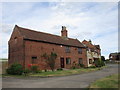
2
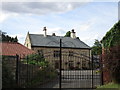
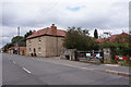
Yews Farmhouse
A sixteenth century timber framed house hidden behind an eighteenth century facade. http://www.britishlistedbuildings.co.uk/en-420566-yews-farmhouse-styrrup-with-oldcotes-not#.V6W6T0fkoeU
Image: © Jonathan Thacker
Taken: 5 Aug 2016
0.04 miles
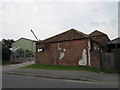
3
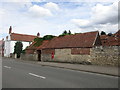
Outbuildings on Main Street, Styrrup
Image: © Jonathan Thacker
Taken: 5 Aug 2016
0.06 miles
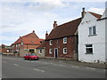
6
Hall Farm Cottage
Appears to have been both house and farm building under one roof.
Image: © Jonathan Thacker
Taken: 5 Aug 2016
0.08 miles
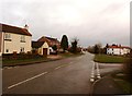
8
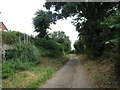
Pinfold Lane
Truncated by the A1(M).
Image: © Jonathan Thacker
Taken: 5 Aug 2016
0.10 miles