IMAGES TAKEN NEAR TO
Streatfield Crescent, DONCASTER, DN11 0SP
Introduction
This page details the photographs taken nearby to Streatfield Crescent, DN11 0SP by members of the Geograph project.
The Geograph project started in 2005 with the aim of publishing, organising and preserving representative images for every square kilometre of Great Britain, Ireland and the Isle of Man.

There are currently over 7.5m images from over14,400 individuals and you can help contribute to the project by visiting https://www.geograph.org.uk
Image Map
Images are licensed for reuse under creativecommons.org/licenses/by-sa/2.0
Notes
- Clicking on the map will re-center to the selected point.
- The higher the marker number, the further away the image location is from the centre of the postcode.
Image Listing (20 Images Found)
Images are licensed for reuse under creativecommons.org/licenses/by-sa/2.0
Image
Details
Distance
1
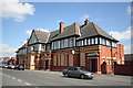
Royal Hotel, Rossington
Closed and boarded up in April 2006
Image: © Richard Croft
Taken: 28 Apr 2006
0.04 miles
3
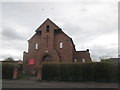
Christ the King Catholic Church, New Rossington
Image: © John Slater
Taken: 23 Mar 2015
0.09 miles
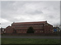
5
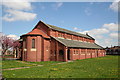
Church of St.Luke the Evangelist, New Rossington
Parish church for the colliery village of New Rossington, built c1925.
Image: © Richard Croft
Taken: 28 Apr 2006
0.09 miles
7
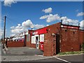
Get Rich Quick Scheme
Betting shop in New Rossington
Image: © Neil Theasby
Taken: 9 Aug 2014
0.10 miles
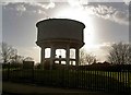
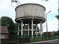
9
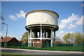
Water Tower
Water tower at New Rossington
Image: © Richard Croft
Taken: 28 Apr 2006
0.11 miles