IMAGES TAKEN NEAR TO
Coxley Mount, DONCASTER, DN11 0NY
Introduction
This page details the photographs taken nearby to Coxley Mount, DN11 0NY by members of the Geograph project.
The Geograph project started in 2005 with the aim of publishing, organising and preserving representative images for every square kilometre of Great Britain, Ireland and the Isle of Man.

There are currently over 7.5m images from over14,400 individuals and you can help contribute to the project by visiting https://www.geograph.org.uk
Image Map
Images are licensed for reuse under creativecommons.org/licenses/by-sa/2.0
Notes
- Clicking on the map will re-center to the selected point.
- The higher the marker number, the further away the image location is from the centre of the postcode.
Image Listing (8 Images Found)
Images are licensed for reuse under creativecommons.org/licenses/by-sa/2.0
Image
Details
Distance
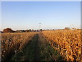
1
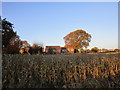
Maize field and houses
On the edge of Littleworth.
Image: © Jonathan Thacker
Taken: 17 Nov 2018
0.03 miles
2
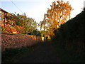
Footpath to Rossington Hall
Starts in the former hamlet of Littleworth which is now wholly subsumed within Rossington.
Image: © Jonathan Thacker
Taken: 17 Nov 2018
0.03 miles
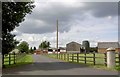
4
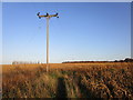
Turn right at the pole
Footpath from Rossington towards Rossington Hall.
Image: © Jonathan Thacker
Taken: 17 Nov 2018
0.12 miles
5
Turn left at the pole for Rossington
Footpath through the maize near Littleworth.
Image: © Jonathan Thacker
Taken: 17 Nov 2018
0.13 miles
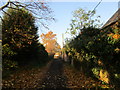
7
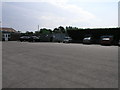
Outdoor Car Park
This car park is for customers of Don Valley Outdoor Centre.
Image: © Michael Patterson
Taken: 26 Jul 2006
0.24 miles
8
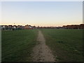
Footpath on the edge of Rossington
Crosses a recreation ground.
Image: © Jonathan Thacker
Taken: 17 Nov 2018
0.25 miles