IMAGES TAKEN NEAR TO
Low Field Lane, DONCASTER, DN10 6RH
Introduction
This page details the photographs taken nearby to Low Field Lane, DN10 6RH by members of the Geograph project.
The Geograph project started in 2005 with the aim of publishing, organising and preserving representative images for every square kilometre of Great Britain, Ireland and the Isle of Man.

There are currently over 7.5m images from over14,400 individuals and you can help contribute to the project by visiting https://www.geograph.org.uk
Image Map
Images are licensed for reuse under creativecommons.org/licenses/by-sa/2.0
Notes
- Clicking on the map will re-center to the selected point.
- The higher the marker number, the further away the image location is from the centre of the postcode.
Image Listing (16 Images Found)
Images are licensed for reuse under creativecommons.org/licenses/by-sa/2.0
Image
Details
Distance
2
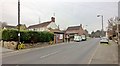
Evidence that Tour de Yorkshire came through here
The yellow bikes remain on both sides of the road to remind us that the tour passed through Austerfield along the A614 towards Doncaster on 30th April 2016.
Image: © Chris Morgan
Taken: 12 Dec 2016
0.06 miles

4
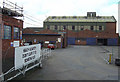
Don't leave it to someone else
The main entrance to Bawtry Carbon International. This firm makes carbon based products mainly for the aluminium industry.
Image: © Alan Murray-Rust
Taken: 22 Jul 2007
0.12 miles

7
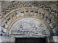
Tympanum over the south doorway, Austerfield church
It is believed that this curious tympanum is eighth century though The Parish Church of Saint Helena is reckoned to be eleventh century. It has been suggested that the tympanum's carvings, surrounding the figure of a dragon, symbolise the means by which Easter Day is calculated in the Christian church.
Image: © Neil Theasby
Taken: 14 Mar 2016
0.17 miles
8

Oilseed rape crop near Austerfield
East of the A614.
Image: © JThomas
Taken: 28 Jun 2014
0.18 miles
9
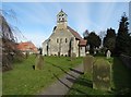
The Parish Church of Saint Helena, Austerfield
Image: © Neil Theasby
Taken: 14 Mar 2016
0.18 miles
10
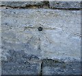
Ordnance Survey 1GL Bolt
This OS Bolt can be found on the west face of St Helena's Church. It marks a point 10.8600m above mean sea level.
Image: © Adrian Dust
Taken: 23 May 2016
0.18 miles