IMAGES TAKEN NEAR TO
Western Walk, DONCASTER, DN10 6PW
Introduction
This page details the photographs taken nearby to Western Walk, DN10 6PW by members of the Geograph project.
The Geograph project started in 2005 with the aim of publishing, organising and preserving representative images for every square kilometre of Great Britain, Ireland and the Isle of Man.

There are currently over 7.5m images from over14,400 individuals and you can help contribute to the project by visiting https://www.geograph.org.uk
Image Map (Loading...)


Getting Data...Please wait
Leaflet Map data © OpenStreetMap
Images are licensed for reuse under creativecommons.org/licenses/by-sa/2.0
Notes
- Clicking on the map will re-center to the selected point.
- The higher the marker number, the further away the image location is from the centre of the postcode.
Image Listing (20 Images Found)
Images are licensed for reuse under creativecommons.org/licenses/by-sa/2.0
Image
Details
Distance
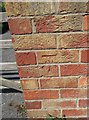
1
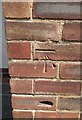
Ordnance Survey Cut Mark
This OS cut mark can be found on the Communal Hall, Doncaster Road. It marks a point 17.928m above mean sea level.
Image: © Adrian Dust
Taken: 6 Jun 2016
0.03 miles
4
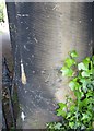
Ordnance Survey Cut Mark
This OS cut mark can be found on the Cemetery gatepost on Doncaster Road. It marks a point 15.619m above mean sea level.
Image: © Adrian Dust
Taken: 6 Jun 2016
0.15 miles
5
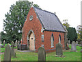
Bawtry - cemetery chapel
The cemetery is off Doncaster Road. The plaque on the door of this extremely small chapel says "St Nicholas Church - Chapel of All Souls".
Image: © Dave Bevis
Taken: 27 Oct 2014
0.15 miles
6
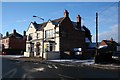
The Station Hotel Bawtry
It's a long time ago since there was any Railway Station at Bawtry but the Station Hotel is still going strong , close to the East Coast Main Line.
Image: © roger geach
Taken: 25 Dec 2010
0.18 miles
7
Ordnance Survey Cut Mark
This OS cut mark can be found on the gatepost of No 32 Ingham road. It marks a point 21.909m above mean sea level.
Image: © Adrian Dust
Taken: 6 Jun 2016
0.18 miles
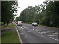
8
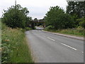
Bawtry Station
The east coast mainline crosses the A614 in Bawtry. Just to the right (north) of the bridge is the site of the former station.
Image: © Michael Patterson
Taken: 30 Jun 2006
0.20 miles
9
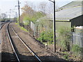
Bawtry railway station (site), Nottinghamshire
Opened in 1849 by the Great Northern Railway on its line from Peterborough to Doncaster, and closed in 1971. View south from a passing train, towards Retford and Peterborough. The railings give away the location of the platform end.
Image: © Nigel Thompson
Taken: 20 Apr 2012
0.21 miles
10
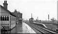
Bawtry Station
View northward (in pouring rain), towards Doncaster etc.; ex-GNR East Coast Main Line, King's Cross - Doncaster etc.. This station was closed to passengers on 6/10/58, to goods 30/4/71. By the signalbox, the Goods branch to Misson turned off to the right, but was closed on 7/12/64.
Image: © Ben Brooksbank
Taken: 19 May 1967
0.21 miles