IMAGES TAKEN NEAR TO
Wellington Grove, DONCASTER, DN10 6PJ
Introduction
This page details the photographs taken nearby to Wellington Grove, DN10 6PJ by members of the Geograph project.
The Geograph project started in 2005 with the aim of publishing, organising and preserving representative images for every square kilometre of Great Britain, Ireland and the Isle of Man.

There are currently over 7.5m images from over14,400 individuals and you can help contribute to the project by visiting https://www.geograph.org.uk
Image Map
Images are licensed for reuse under creativecommons.org/licenses/by-sa/2.0
Notes
- Clicking on the map will re-center to the selected point.
- The higher the marker number, the further away the image location is from the centre of the postcode.
Image Listing (7 Images Found)
Images are licensed for reuse under creativecommons.org/licenses/by-sa/2.0
Image
Details
Distance
1
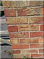
Ordnance Survey Cut Mark
This OS cut mark can be found on the gatepost of No 32 Ingham road. It marks a point 21.909m above mean sea level.
Image: © Adrian Dust
Taken: 6 Jun 2016
0.11 miles
2
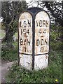
Old Milepost by the A638, Bawtry
Cast iron post by the A638, in parish of Austerfield (Doncaster District), North end of Bawtry, almost opposite Water Tower, on grass verge at lay-by, on East side of road. Walkinshaw iron casting, erected by the Doncaster & Bawtry turnpike trust in the 19th century.
Inscription reads:-
: LON / 154 / -- / BAW / 1 / ---- / J.MAW/1859/COMR.DONR. : : YORK / 44 / -- / DON / 8 / ---- / J.WALKINSHAW/DONR./IRON.FOUNDER :
Grade II listed.
List Entry Number: 1151576 https://historicengland.org.uk/listing/the-list/list-entry/1151576
Milestone Society National ID: YS_DNBW08
Image: © C Minto
Taken: 1 Aug 1995
0.20 miles
3
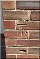
Ordnance Survey Cut Mark
This OS cut mark can be found on the Communal Hall, Doncaster Road. It marks a point 17.928m above mean sea level.
Image: © Adrian Dust
Taken: 6 Jun 2016
0.22 miles
5
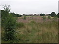
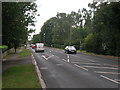
Gally Hills
The houses of Bawtry slowly creep northwards towards this area called Gally Hills, by the side of Kings Wood.
Image: © Michael Patterson
Taken: 7 Aug 2006
0.23 miles
6
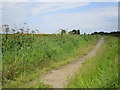
Path off Martin Lane
Leads to housing on the north-west fringe of Bawtry.
Image: © Jonathan Thacker
Taken: 21 Jun 2014
0.24 miles