IMAGES TAKEN NEAR TO
Bracken Hill Lane, DONCASTER, DN10 6EP
Introduction
This page details the photographs taken nearby to Bracken Hill Lane, DN10 6EP by members of the Geograph project.
The Geograph project started in 2005 with the aim of publishing, organising and preserving representative images for every square kilometre of Great Britain, Ireland and the Isle of Man.

There are currently over 7.5m images from over14,400 individuals and you can help contribute to the project by visiting https://www.geograph.org.uk
Image Map
Images are licensed for reuse under creativecommons.org/licenses/by-sa/2.0
Notes
- Clicking on the map will re-center to the selected point.
- The higher the marker number, the further away the image location is from the centre of the postcode.
Image Listing (6 Images Found)
Images are licensed for reuse under creativecommons.org/licenses/by-sa/2.0
Image
Details
Distance

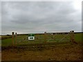
2
Highwood Farm
This is in fact a complex of several farming business, including retail outlets.
Image: © Alan Murray-Rust
Taken: 5 Aug 2007
0.07 miles
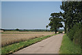
3
View towards Highwood Farm
Taken from Rugged Butts Lane.
Image: © Jonathan Thacker
Taken: 28 Jan 2012
0.09 miles
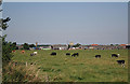
4
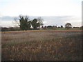
View towards Highwood Farm
The slight rise is Bracken Hill.
Image: © Jonathan Thacker
Taken: 28 Jan 2012
0.18 miles