IMAGES TAKEN NEAR TO
Slaynes Lane, DONCASTER, DN10 6DY
Introduction
This page details the photographs taken nearby to Slaynes Lane, DN10 6DY by members of the Geograph project.
The Geograph project started in 2005 with the aim of publishing, organising and preserving representative images for every square kilometre of Great Britain, Ireland and the Isle of Man.

There are currently over 7.5m images from over14,400 individuals and you can help contribute to the project by visiting https://www.geograph.org.uk
Image Map
Images are licensed for reuse under creativecommons.org/licenses/by-sa/2.0
Notes
- Clicking on the map will re-center to the selected point.
- The higher the marker number, the further away the image location is from the centre of the postcode.
Image Listing (61 Images Found)
Images are licensed for reuse under creativecommons.org/licenses/by-sa/2.0
Image
Details
Distance

3
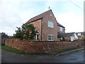
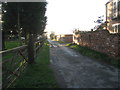
Farm View
Detached property on West Street
Image: © Graham Hogg
Taken: 12 Dec 2016
0.02 miles
4
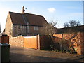
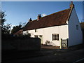
Reeds Cottage
A much restored seventeenth century house. http://www.britishlistedbuildings.co.uk/en-241151-reeds-cottage-misson
Image: © Jonathan Thacker
Taken: 28 Jan 2012
0.03 miles
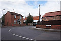

8
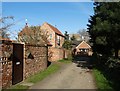
Bull Hill Farm
Bull Hill Farm is located right in the village centre of Misson.
Image: © Michael Patterson
Taken: 27 Mar 2006
0.06 miles
9
Cookson's Cottage
One of Misson's older buildings. http://www.britishlistedbuildings.co.uk/en-241156-cookson-s-house-misson
Image: © Jonathan Thacker
Taken: 28 Jan 2012
0.07 miles