IMAGES TAKEN NEAR TO
Saracens Lane, DONCASTER, DN10 6AS
Introduction
This page details the photographs taken nearby to Saracens Lane, DN10 6AS by members of the Geograph project.
The Geograph project started in 2005 with the aim of publishing, organising and preserving representative images for every square kilometre of Great Britain, Ireland and the Isle of Man.

There are currently over 7.5m images from over14,400 individuals and you can help contribute to the project by visiting https://www.geograph.org.uk
Image Map
Images are licensed for reuse under creativecommons.org/licenses/by-sa/2.0
Notes
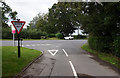
- Clicking on the map will re-center to the selected point.
- The higher the marker number, the further away the image location is from the centre of the postcode.
Image Listing (43 Images Found)
Images are licensed for reuse under creativecommons.org/licenses/by-sa/2.0
Image
Details
Distance
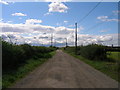
1
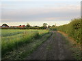
Saracen's Lane
Looking towards Scrooby.
Image: © Jonathan Thacker
Taken: 18 Jun 2014
0.02 miles
2
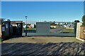
Pilgrim Fathers Caravan and Camping Park, Scrooby
On Saracens Lane
Image: © Neil Theasby
Taken: 17 Jan 2023
0.03 miles
3
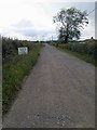
The residents repair and maintain this lane please drive slowly
Unmade lane to Caravan park Scrooby.
Image: © Steve Fareham
Taken: 11 Jun 2011
0.05 miles
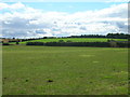
6
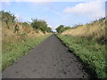
Long Climb Line
This long climb is a former railway branch line which joined the nearby Harworth Colliery with the East Coast Mainline. It is now clearly used to exercise horses.
Image: © Michael Patterson
Taken: 16 Aug 2006
0.15 miles
7
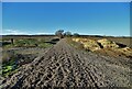
Saracens Lane - former railway crossing
West of Scrooby. A railway used to run along here to Harworth Colliery. Now it seems to be the domain of galloping horses though none thundered by as I stopped to take this picture.
Image: © Neil Theasby
Taken: 17 Jan 2023
0.15 miles
8
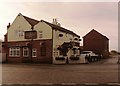
The Pilgrim Fathers Public House in Scrooby
Scrooby has historical connections with the Separatist movement, a religious group who were dissatisfied with the church establishment. Villager William Brewster boarded the Mayflower in 1620 hence the link to this pub's name. The old Great North Road is in the foreground.
Image: © Jonathan Clitheroe
Taken: 23 Jan 2016
0.16 miles
9
Chapel Lane joins the Great North Road, Scrooby
Image: © Ian S
Taken: 29 Aug 2020
0.16 miles
10
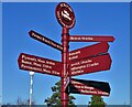
Signpost at Scrooby
Marking four hundred years since The Pilgrim Fathers set sail for Massachusetts (1620-2020). Scrooby has long been associated with this episode in American history being the original home of William Bradford - one of the mission's leaders. Incidentally someone appears to have made an error with regard to the distance to Plymouth, Massachusetts.
Image: © Neil Theasby
Taken: 17 Jan 2023
0.16 miles