IMAGES TAKEN NEAR TO
Meadow View, DN10 5FA
Introduction
This page details the photographs taken nearby to Meadow View, DN10 5FA by members of the Geograph project.
The Geograph project started in 2005 with the aim of publishing, organising and preserving representative images for every square kilometre of Great Britain, Ireland and the Isle of Man.

There are currently over 7.5m images from over14,400 individuals and you can help contribute to the project by visiting https://www.geograph.org.uk
Image Map (12 Images)


Getting Data...Please wait
Leaflet Map data © OpenStreetMap
Images are licensed for reuse under creativecommons.org/licenses/by-sa/2.0
Notes
- Clicking on the map will re-center to the selected point.
- The higher the marker number, the further away the image location is from the centre of the postcode.
Image Listing (12 Images Found)
Images are licensed for reuse under creativecommons.org/licenses/by-sa/2.0
Image
Details
Distance
1
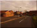
Road Junction at Mattersey Thorpe
Image: © Jonathan Clitheroe
Taken: 23 Jan 2016
0.05 miles
3
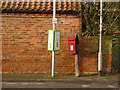
Mattersey Thorpe postbox ref DN10 148
Standard EIIR lampbox on a rather decayed stump of a telegraph pole.
Image: © Alan Murray-Rust
Taken: 24 Nov 2014
0.06 miles
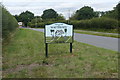
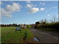
5
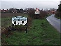
Entering Mattersey Thorpe on Breck Lane
Image: © Neil Theasby
Taken: 5 Jan 2016
0.08 miles
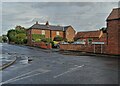
6

Bleak House Farmhouse, Mattersey Thorpe
This is the building on the left. Early 19th century farmhouse, Listed Grade II.
Image: © Alan Murray-Rust
Taken: 24 Nov 2014
0.11 miles
8
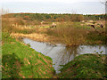
River Idle near Mattersey
Running alongside Thorpe Road.
Image: © Alan Murray-Rust
Taken: 24 Nov 2014
0.17 miles
9
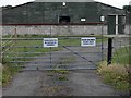
Trespassers will be disposed of humanely!
Interesting signs on a number of what look like chicken sheds on Breck Lane?
Image: © Steve Fareham
Taken: 11 Jun 2011
0.18 miles
10
Cemetery at Mattersey and Mattersey Thorpe
Image: © Chris Morgan
Taken: 11 Aug 2015
0.22 miles