IMAGES TAKEN NEAR TO
Main Street, DONCASTER, DN10 5DT
Introduction
This page details the photographs taken nearby to Main Street, DN10 5DT by members of the Geograph project.
The Geograph project started in 2005 with the aim of publishing, organising and preserving representative images for every square kilometre of Great Britain, Ireland and the Isle of Man.

There are currently over 7.5m images from over14,400 individuals and you can help contribute to the project by visiting https://www.geograph.org.uk
Image Map (Loading...)


Getting Data...Please wait
Leaflet Map data © OpenStreetMap
Images are licensed for reuse under creativecommons.org/licenses/by-sa/2.0
Notes
- Clicking on the map will re-center to the selected point.
- The higher the marker number, the further away the image location is from the centre of the postcode.
Image Listing (93 Images Found)
Images are licensed for reuse under creativecommons.org/licenses/by-sa/2.0
Image
Details
Distance
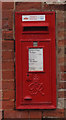
1
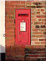
Mattersey P.O. Main Street Mattersey postbox, ref DN10 90
Standard GVIR wall box.
Image: © Alan Murray-Rust
Taken: 24 Nov 2014
0.00 miles
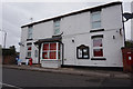
5
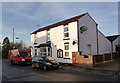
Mattersey Post Office and village store
Close up of the postbox here http://www.geograph.org.uk/photo/4260538
Image: © Alan Murray-Rust
Taken: 24 Nov 2014
0.02 miles
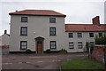
9
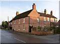
Hall Farm, Mattersey
Early 19th century farmhouse, formerly rendered but now in natural brick. Listed Grade II.
Image: © Alan Murray-Rust
Taken: 24 Nov 2014
0.03 miles
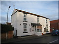
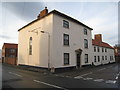
10
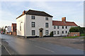
Barley Mow House, Mattersey
Formerly the Barley Mow public house. The road it fronts, Church Lane, used to be the main road north out of the village. Late 18th century, Listed Grade II. The broad chimney stack on the extension suggests that there might have been a brewhouse in this section.
Image: © Alan Murray-Rust
Taken: 24 Nov 2014
0.03 miles