IMAGES TAKEN NEAR TO
Pusto Hill Lane, DONCASTER, DN10 5DB
Introduction
This page details the photographs taken nearby to Pusto Hill Lane, DN10 5DB by members of the Geograph project.
The Geograph project started in 2005 with the aim of publishing, organising and preserving representative images for every square kilometre of Great Britain, Ireland and the Isle of Man.

There are currently over 7.5m images from over14,400 individuals and you can help contribute to the project by visiting https://www.geograph.org.uk
Image Map
Images are licensed for reuse under creativecommons.org/licenses/by-sa/2.0
Notes
- Clicking on the map will re-center to the selected point.
- The higher the marker number, the further away the image location is from the centre of the postcode.
Image Listing (7 Images Found)
Images are licensed for reuse under creativecommons.org/licenses/by-sa/2.0
Image
Details
Distance
1
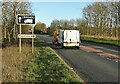
The A631 east of Everton
Near the Drakeholes junction
Image: © Neil Theasby
Taken: 19 Nov 2020
0.08 miles

5
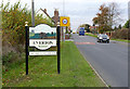
Village entrance sign at Everton
The presence of the wild boar on the sign is well explained below.
Image: © Alan Murray-Rust
Taken: 4 Nov 2014
0.15 miles
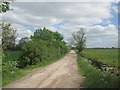
6
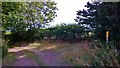
Junction of Pusto Hill Lane and Mill Lane, near Everton
Image: © Chris Morgan
Taken: 11 Aug 2015
0.16 miles