IMAGES TAKEN NEAR TO
Everton, DONCASTER, DN10 5DA
Introduction
This page details the photographs taken nearby to DN10 5DA by members of the Geograph project.
The Geograph project started in 2005 with the aim of publishing, organising and preserving representative images for every square kilometre of Great Britain, Ireland and the Isle of Man.

There are currently over 7.5m images from over14,400 individuals and you can help contribute to the project by visiting https://www.geograph.org.uk
Image Map (Loading...)


Getting Data...Please wait
Leaflet Map data © OpenStreetMap
Images are licensed for reuse under creativecommons.org/licenses/by-sa/2.0
Notes
- Clicking on the map will re-center to the selected point.
- The higher the marker number, the further away the image location is from the centre of the postcode.
Image Listing (3 Images Found)
Images are licensed for reuse under creativecommons.org/licenses/by-sa/2.0
Image
Details
Distance
1
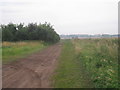
Black Bank near Everton
Looking towards Cuckoo Hill.
Image: © Jonathan Thacker
Taken: 31 Jul 2012
0.05 miles
2
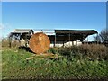
At Roe Lane Farm
The circular object in the foreground is actually the bottom of a large slurry tank turned on its side. The Dutch barn behind it has seen better days.
Image: © Neil Theasby
Taken: 19 Nov 2020
0.07 miles
3
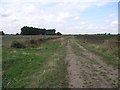
Everton Carr Bridleway
This bridleway crosses over Everton Carr on its way to Everton Carr Farm.
Image: © Michael Patterson
Taken: 16 Aug 2006
0.09 miles