IMAGES TAKEN NEAR TO
Lancaster Road, DONCASTER, DN10 4RL
Introduction
This page details the photographs taken nearby to Lancaster Road, DN10 4RL by members of the Geograph project.
The Geograph project started in 2005 with the aim of publishing, organising and preserving representative images for every square kilometre of Great Britain, Ireland and the Isle of Man.

There are currently over 7.5m images from over14,400 individuals and you can help contribute to the project by visiting https://www.geograph.org.uk
Image Map (Loading...)


Getting Data...Please wait
Leaflet Map data © OpenStreetMap
Images are licensed for reuse under creativecommons.org/licenses/by-sa/2.0
Notes
- Clicking on the map will re-center to the selected point.
- The higher the marker number, the further away the image location is from the centre of the postcode.
Image Listing (43 Images Found)
Images are licensed for reuse under creativecommons.org/licenses/by-sa/2.0
Image
Details
Distance
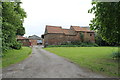
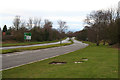
3
The A631 by-passing Gringley on the Hill
The Trent Valley Way crosses here
Image: © Tim Heaton
Taken: 19 Jun 2015
0.04 miles

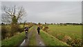
5
Trent Valley Way south of Gringley-on-the-Hill
The mast on Beacon Hill just visible
Image: © John Slater
Taken: 23 Feb 2016
0.06 miles
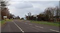
6
Gringley on the Hill
The A631 looking west
Image: © roger geach
Taken: 26 Dec 2011
0.07 miles
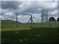
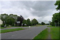
9
Beacon Hill
Just away from the highest point of Beacon Hill at Gringley are situated a radio mast and water tower.
Image: © David Squire
Taken: 11 May 2006
0.10 miles
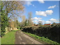
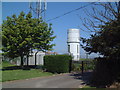
10
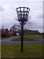
Gringley beacon.
Situated by roadside close to Beacon hill.
Image: © steven ruffles
Taken: 6 Mar 2010
0.11 miles