IMAGES TAKEN NEAR TO
Wood Lane, DONCASTER, DN10 4NX
Introduction
This page details the photographs taken nearby to Wood Lane, DN10 4NX by members of the Geograph project.
The Geograph project started in 2005 with the aim of publishing, organising and preserving representative images for every square kilometre of Great Britain, Ireland and the Isle of Man.

There are currently over 7.5m images from over14,400 individuals and you can help contribute to the project by visiting https://www.geograph.org.uk
Image Map (Loading...)


Getting Data...Please wait
Leaflet Map data © OpenStreetMap
Images are licensed for reuse under creativecommons.org/licenses/by-sa/2.0
Notes
- Clicking on the map will re-center to the selected point.
- The higher the marker number, the further away the image location is from the centre of the postcode.
Image Listing (5 Images Found)
Images are licensed for reuse under creativecommons.org/licenses/by-sa/2.0
Image
Details
Distance
1
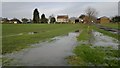
Wood Farm
Amidst paddy fields on this day!
Image: © Chris Morgan
Taken: 24 Nov 2014
0.01 miles
2
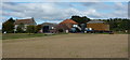
Wood Farm from the south
Looking across the field to the farm from the public track.
Image: © Andrew Hill
Taken: 25 Sep 2010
0.02 miles
3
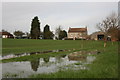
Wood Farm
Reflected in a large puddle in the field following recent heavy rain
Image: © Graham Hogg
Taken: 24 Nov 2014
0.02 miles
4
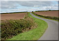
Looking north along Wood Lane
The lane rises gently before turning right and heading directly east towards Beckingham.
Image: © Andrew Hill
Taken: 25 Sep 2010
0.22 miles
5
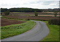
Lane towards Wood Farm
The lane curves with views opening out as the corner is approached from the east.
Image: © Andrew Hill
Taken: 25 Sep 2010
0.24 miles