IMAGES TAKEN NEAR TO
Orchard Rise, DONCASTER, DN10 4NG
Introduction
This page details the photographs taken nearby to Orchard Rise, DN10 4NG by members of the Geograph project.
The Geograph project started in 2005 with the aim of publishing, organising and preserving representative images for every square kilometre of Great Britain, Ireland and the Isle of Man.

There are currently over 7.5m images from over14,400 individuals and you can help contribute to the project by visiting https://www.geograph.org.uk
Image Map (Loading...)


Getting Data...Please wait
Leaflet Map data © OpenStreetMap
Images are licensed for reuse under creativecommons.org/licenses/by-sa/2.0
Notes
- Clicking on the map will re-center to the selected point.
- The higher the marker number, the further away the image location is from the centre of the postcode.
Image Listing (100 Images Found)
Images are licensed for reuse under creativecommons.org/licenses/by-sa/2.0
Image
Details
Distance
1
The Old Post Office (left) and former village store
The post office in the village had quite a wandering existence before reaching its current location. See the local village website for a detailed history http://www.beckingham-northnotts.org.uk/history/vshoppo.html
Image: © Alan Murray-Rust
Taken: 4 Nov 2014
0.04 miles
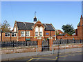
2
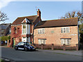
Beckingham Primary School
This school seems to have managed to hang on to its original iron railings during WW2 when most lost them to be melted down as scrap to make armaments and other necessary steel products.
Image: © Chris Morgan
Taken: 24 Nov 2014
0.05 miles
3
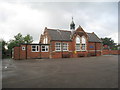
Beckingham Primary School
Built in the same style as several nearby buildings.
Image: © Jonathan Thacker
Taken: 6 Jul 2012
0.05 miles
5
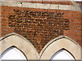
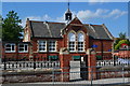
Beckingham Board Schools 1901
A fine example of moulded terracotta work in brick-sized units. See http://www.geograph.org.uk/photo/4236039 for location.
Image: © Alan Murray-Rust
Taken: 4 Nov 2014
0.05 miles
6
Beckingham Primary School
Dating from 1901 - see detail of the inscription here http://www.geograph.org.uk/photo/4236040.
Image: © Alan Murray-Rust
Taken: 4 Nov 2014
0.05 miles
7
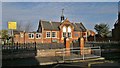
Beckingham Primary School
Originally the Beckingham Board School, built in 1901
Image: © Graham Hogg
Taken: 24 Nov 2014
0.05 miles
8
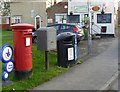
Beckingham Post Office postbox ref DN10 469
Standard EIIR (Royal Mail) pillar box. The box was not the usual replacement for a built-in box at a post office when the Royal Mail was split off, but was installed at the request of the village in 2005 because the existing wall box in the former Primitive Methodist Chapel was too small for the amount of mail. See also http://www.beckingham-northnotts.org.uk/history/vshoppo.html
Image: © Alan Murray-Rust
Taken: 4 Nov 2014
0.07 miles
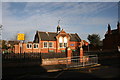
9
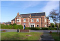
Beckingham Institute
The Institute was founded by local shipyard owner Joseph Spencer Compton Watson in 1908, and the adjacent houses were for letting to Institute members. The institute occupies this side of the building, together with a caretaker's flat, and included a reading room and games facility, currently including pool, snooker and darts. For more information, see the excellent local history site http://www.beckingham-northnotts.org.uk/history/institute.htm.
Image: © Alan Murray-Rust
Taken: 4 Nov 2014
0.07 miles
10

Beckingham village shop and Post Office
The building housing the shop is believed to have been originally a pair of almshouses.
Image: © Alan Murray-Rust
Taken: 4 Nov 2014
0.07 miles