IMAGES TAKEN NEAR TO
Walkeringham, DONCASTER, DN10 4NA
Introduction
This page details the photographs taken nearby to DN10 4NA by members of the Geograph project.
The Geograph project started in 2005 with the aim of publishing, organising and preserving representative images for every square kilometre of Great Britain, Ireland and the Isle of Man.

There are currently over 7.5m images from over14,400 individuals and you can help contribute to the project by visiting https://www.geograph.org.uk
Image Map (Loading...)


Getting Data...Please wait
Leaflet Map data © OpenStreetMap
Images are licensed for reuse under creativecommons.org/licenses/by-sa/2.0
Notes
- Clicking on the map will re-center to the selected point.
- The higher the marker number, the further away the image location is from the centre of the postcode.
Image Listing (16 Images Found)
Images are licensed for reuse under creativecommons.org/licenses/by-sa/2.0
Image
Details
Distance
1
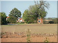
Leys Farm sheltered by trees
Seen from a boat on the Chesterfield Canal.
Image: © Christine Johnstone
Taken: 14 Oct 2011
0.02 miles
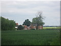
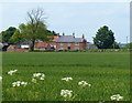
5
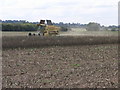
Dusty Harvest
The recent dry weather has been kind to the harvest if not the growth of crops this year.
Image: © Michael Patterson
Taken: 16 Aug 2006
0.07 miles
6
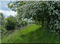
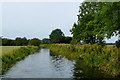
Cuckoo Way heading west along the Chesterfield Canal
Image: © Mat Fascione
Taken: 28 May 2016
0.13 miles
7
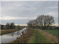
The Chesterfield Canal
Walking along the Cuckoo Way.
Image: © steven ruffles
Taken: 18 Dec 2016
0.14 miles
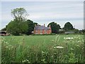
9
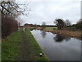
Chesterfield Canal
A peaceful section of the canal near Gringley. The towpath is used by the Trent Valley Way and the Cuckoo Way.
Image: © Graham Horn
Taken: 23 Sep 2012
0.16 miles
10

Gate on the towpath of the Chesterfield Canal
Image: © Mat Fascione
Taken: 28 May 2016
0.16 miles