IMAGES TAKEN NEAR TO
West Moor Road, DONCASTER, DN10 4LR
Introduction
This page details the photographs taken nearby to West Moor Road, DN10 4LR by members of the Geograph project.
The Geograph project started in 2005 with the aim of publishing, organising and preserving representative images for every square kilometre of Great Britain, Ireland and the Isle of Man.

There are currently over 7.5m images from over14,400 individuals and you can help contribute to the project by visiting https://www.geograph.org.uk
Image Map (Loading...)


Getting Data...Please wait
Leaflet Map data © OpenStreetMap
Images are licensed for reuse under creativecommons.org/licenses/by-sa/2.0
Notes
- Clicking on the map will re-center to the selected point.
- The higher the marker number, the further away the image location is from the centre of the postcode.
Image Listing (5 Images Found)
Images are licensed for reuse under creativecommons.org/licenses/by-sa/2.0
Image
Details
Distance
1
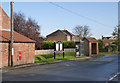
Communications hub, North Moor Road, Walkeringham
Postbox http://www.geograph.org.uk/photo/4241828, Village Notice Board, Telephone kiosk and bus shelter. This part of the village however no longer enjoys a bus service.
Image: © Alan Murray-Rust
Taken: 9 Nov 2014
0.11 miles
2
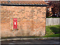
Moorend - North Moor Road postbox DN10 227
Early style EVIIR wall box with wide posting slot.
Image: © Alan Murray-Rust
Taken: 9 Nov 2014
0.11 miles
3
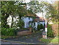
Cottage at Moor End Farm
18th century cottage with later outbuilding beyond. Listed Grade II.
Image: © Alan Murray-Rust
Taken: 9 Nov 2014
0.12 miles
5
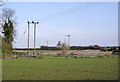
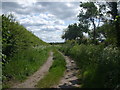
View north east from Fountain Hill Lane
The electricity lines take a distinctly zig-zag course.
Image: © Alan Murray-Rust
Taken: 9 Nov 2014
0.22 miles