IMAGES TAKEN NEAR TO
School House Lane, DONCASTER, DN10 4LF
Introduction
This page details the photographs taken nearby to School House Lane, DN10 4LF by members of the Geograph project.
The Geograph project started in 2005 with the aim of publishing, organising and preserving representative images for every square kilometre of Great Britain, Ireland and the Isle of Man.

There are currently over 7.5m images from over14,400 individuals and you can help contribute to the project by visiting https://www.geograph.org.uk
Image Map
Images are licensed for reuse under creativecommons.org/licenses/by-sa/2.0
Notes
- Clicking on the map will re-center to the selected point.
- The higher the marker number, the further away the image location is from the centre of the postcode.
Image Listing (6 Images Found)
Images are licensed for reuse under creativecommons.org/licenses/by-sa/2.0
Image
Details
Distance
1
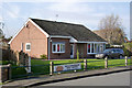
Walkeringham Post Office
The long-standing tradition of postal facilities being offered from a private residence is alive and well here. The Post Office is at the far end of the bungalow.
Image: © Alan Murray-Rust
Taken: 9 Nov 2014
0.08 miles
2
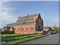
Walkeringham Methodist Chapel
Dated 1886, now a private residence.
Image: © Alan Murray-Rust
Taken: 9 Nov 2014
0.09 miles
3
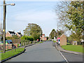
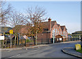
High Street, Walkeringham
Looking north at Mill Baulk Lane.
Image: © Alan Murray-Rust
Taken: 9 Nov 2014
0.10 miles
4

Mail vans outside Walkeringham Post Office
This appears to be a local hub for collections and deliveries.
Image: © Alan Murray-Rust
Taken: 9 Nov 2014
0.10 miles
5
Walkeringham Primary School
The older part of the building dates from 1913.
Image: © Alan Murray-Rust
Taken: 9 Nov 2014
0.12 miles