IMAGES TAKEN NEAR TO
Swallow Court, DONCASTER, DN10 4DA
Introduction
This page details the photographs taken nearby to Swallow Court, DN10 4DA by members of the Geograph project.
The Geograph project started in 2005 with the aim of publishing, organising and preserving representative images for every square kilometre of Great Britain, Ireland and the Isle of Man.

There are currently over 7.5m images from over14,400 individuals and you can help contribute to the project by visiting https://www.geograph.org.uk
Image Map (76 Images)


Getting Data...Please wait
Leaflet Map data © OpenStreetMap
Images are licensed for reuse under creativecommons.org/licenses/by-sa/2.0
Notes
- Clicking on the map will re-center to the selected point.
- The higher the marker number, the further away the image location is from the centre of the postcode.
Image Listing (76 Images Found)
Images are licensed for reuse under creativecommons.org/licenses/by-sa/2.0
Image
Details
Distance
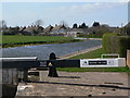
1
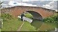
Swallow Bridge, No 82, on Chesterfield Canal
Image: © Chris Morgan
Taken: 3 Sep 2013
0.04 miles
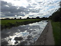
2

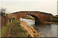
Chesterfield Canal
View east along the towpath at Misterton towards Swallow Bridge http://www.geograph.org.uk/photo/2810432
Image: © Richard Croft
Taken: 16 Feb 2012
0.04 miles
3
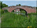
Swallow Bridge
Bridge number 82 over the Chesterfield Canal at Misterton
Image: © Richard Croft
Taken: 16 Feb 2012
0.04 miles
4

Bridge 82, Chesterfield Canal
Swallow Bridge, Misterfield is a farm access bridge, not a road bridge.
Image: © Christine Johnstone
Taken: 14 Oct 2011
0.04 miles
5

The Chesterfield Canal at Misterton
In the distance is Swallow Bridge No 82.
Image: © Mat Fascione
Taken: 28 May 2016
0.05 miles
6
Swallow Bridge No 82
Crossing the Chesterfield Canal and Cuckoo Way in Misterton.
Image: © Mat Fascione
Taken: 28 May 2016
0.05 miles
7
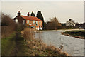
Chesterfield Canal
Canal-side property at Misterton
Image: © Richard Croft
Taken: 16 Feb 2012
0.06 miles
8

Cottage along the Chesterfield Canal at Misterton
Image: © Mat Fascione
Taken: 28 May 2016
0.07 miles
9
Misterton Top Lock
Looking along the reach past Misterton Village.
Image: © Alan Murray-Rust
Taken: 31 Mar 2011
0.07 miles
10
Chesterfield Canal at Misterton at dusk
The Shell Guide to Nottinghamshire says of Misterton: "It is a strange part of the world. The church stands in the centre of the old village, accompanied by older cottages and farms - some with fine buildings and - Nonconformist chapels. The Chesterfield Canal passes through the village on its way to join the Trent at West Stockwith; there is a delightful walk along the towpath."
The Chesterfield Canal officially opened in 1777. It originally extended 46 miles from the River Trent through Misterton, Worksop and Retford before arriving at its terminus in Chesterfield. The last recorded commercial cargo was in the 1960s. In 1976 the Chesterfield Canal Society, now known as the Chesterfield Canal Trust, was formed.
See https://canalrivertrust.org.uk/enjoy-the-waterways/canal-and-river-network/chesterfield-canal?gclid=Cj0KCQjw_OzrBRDmARIsAAIdQ_IIa5LdoWnWvDGea6K4LDOcZvTZRXRJ_tQORSrl3yFk0xZgUclyN2caAkPpEALw_wcB for full details including a map.
Image: © Marathon
Taken: 7 Sep 2019
0.08 miles